
Common Geological Factors that Trigger Landslides
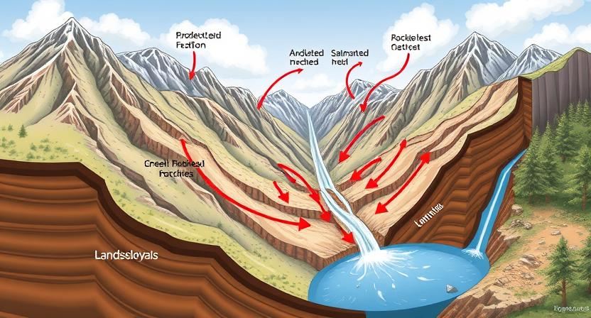
Landslides may occur due to various geological factors. One common trigger is the steepness of slopes, where the force of gravity can easily overcome the strength of the materials holding the slope together. Additionally, the type of rock and soil composition plays a crucial role in landslide susceptibility. Weak or weathered rocks, as well as loose or saturated soils, are more prone to giving way under the influence of external forces.
Another significant geological factor that can trigger landslides is the role of water saturation. Excessive water within the soil increases its weight, decreasing the friction between particles and causing slopes to become unstable. When the water content reaches a critical level, the likelihood of landslides occurring significantly rises. In combination with other factors such as steep slopes or seismic activity, water saturation can act as a catalyst for devastating landslide events.
• Steepness of slopes can easily overcome the strength of materials
• Type of rock and soil composition plays a crucial role in landslide susceptibility
• Weak or weathered rocks, loose or saturated soils are more prone to giving way under external forces
• Water saturation within the soil increases weight and decreases friction between particles
• Excessive water can cause slopes to become unstable
• When water content reaches a critical level, likelihood of landslides significantly rises
Types of Rock and Soil Composition that Increase Landslide Risk
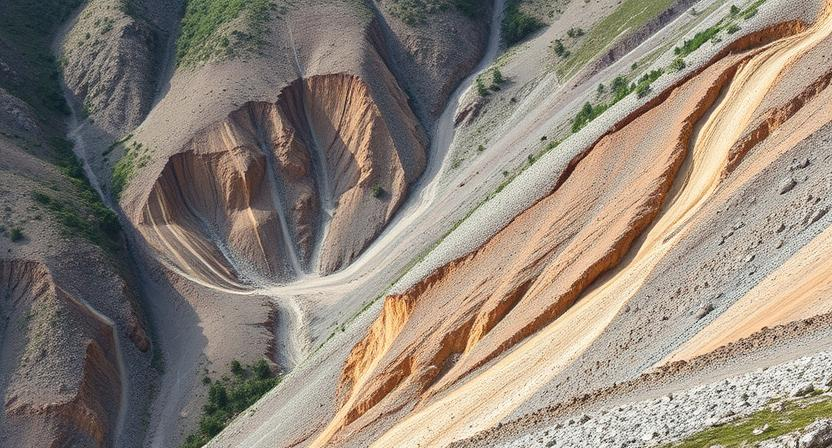
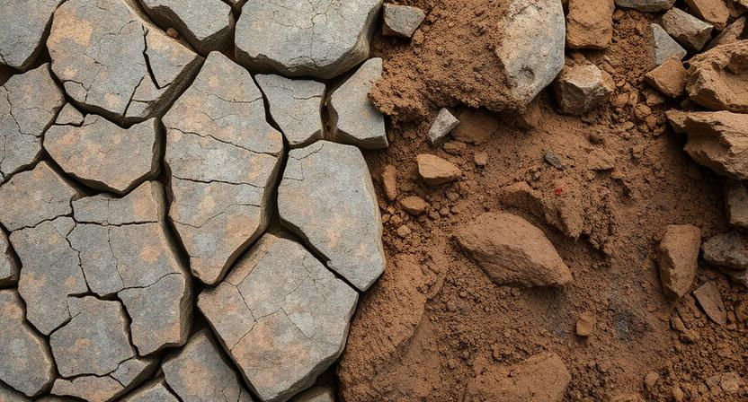
Rock and soil composition play a crucial role in determining the likelihood of landslides occurring in a particular area. Certain types of rock, such as shale and limestone, are more prone to weathering and erosion, increasing the risk of slope failure. Similarly, loose and unconsolidated soils like clay and silt are susceptible to becoming saturated with water, losing their stability, and triggering landslides.
In addition to the type of rock and soil present, the level of compaction and cohesion within these materials can also impact landslide risk. Rocks that are heavily fractured or have weak interlocking bonds are more likely to experience mass movements under the influence of gravity. Similarly, poorly compacted soils with high water content are prone to becoming unstable during heavy rainfall or seismic activity, leading to landslides.
• Shale and limestone are more prone to weathering and erosion
• Loose soils like clay and silt can become saturated with water, increasing landslide risk
• Rocks with weak interlocking bonds are more likely to experience mass movements
• Poorly compacted soils with high water content are susceptible to instability during heavy rainfall or seismic activity
Role of Water Saturation in Landslide Occurrence
Landslides are often triggered by excessive water saturation in the soil or rock layers. When the soil becomes saturated with water, it loses its strength and cohesion, leading to a higher risk of slope failure. The presence of water reduces the friction between soil particles, making it easier for the materials to become unstable and slide downhill.
Moreover, heavy rainfall or rapid snowmelt can further increase the water content in the soil, exacerbating the landslide risk. The additional water seeps into the ground and adds extra weight to the soil mass, pushing it towards instability. Water saturation not only weakens the soil but also adds pressure to the slope, increasing the likelihood of a landslide event.
• Landslides are often triggered by excessive water saturation in the soil or rock layers.
• Saturated soil loses its strength and cohesion, increasing the risk of slope failure.
• Water reduces friction between soil particles, making materials more unstable and prone to sliding downhill.
• Heavy rainfall or rapid snowmelt can increase water content in the soil, further exacerbating landslide risk.
• Additional water adds weight to the soil mass, pushing it towards instability.
• Water saturation weakens the soil and adds pressure to the slope, increasing likelihood of a landslide event.
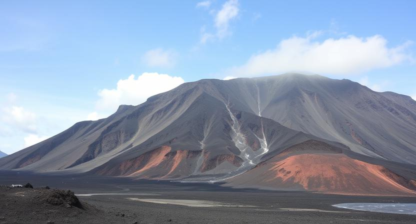
Impact of Steep Slopes on Landslide Susceptibility
Steep slopes play a significant role in increasing the susceptibility of an area to landslides. The angle of incline on a slope affects the stability of the land, with steeper slopes being more prone to sliding due to the gravitational forces acting upon them. The steepness of a slope directly impacts how easily the underlying rock and soil can become destabilized, leading to a higher risk of landslides occurring.
In areas with steep slopes, the force of gravity pulling materials downhill is intensified, making it easier for rocks, soil, and debris to slide or flow downwards under the influence of external factors like heavy rainfall or seismic activity. Steep slopes lack the natural ability to retain materials in place, increasing the likelihood of mass movements such as landslides. Additionally, the erosion of the slope’s surface layers can further weaken the stability of the land, making it more susceptible to sudden failure and landslide events.
• Steep slopes increase susceptibility to landslides due to gravitational forces
• Angle of incline directly impacts stability of land
• Force of gravity intensified in areas with steep slopes, making it easier for materials to slide downhill
• Steep slopes lack natural ability to retain materials, increasing risk of landslides
• Erosion of surface layers on steep slopes weakens stability and increases susceptibility to landslide events
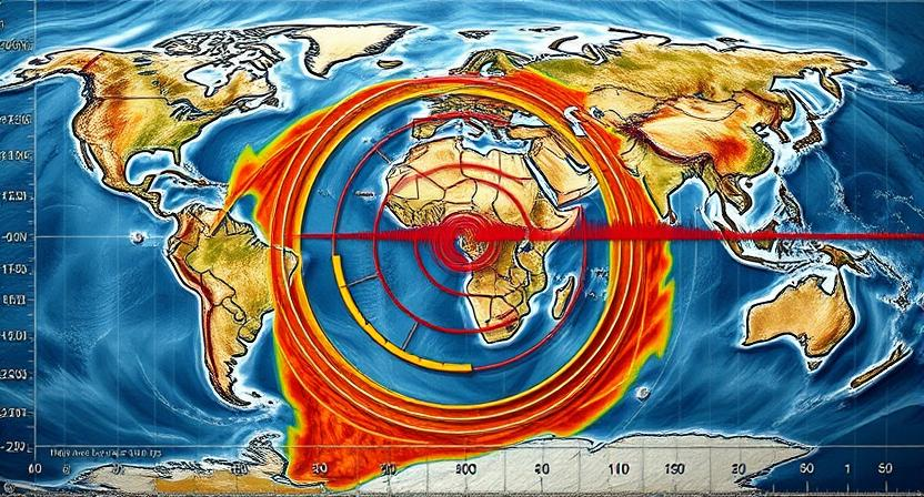
The Influence of Earthquakes on Landslide Activity
Earthquakes play a significant role in triggering landslides due to the sudden ground shaking they generate. The intense vibrations caused by seismic waves can destabilize slopes by decreasing the friction between rock or soil particles, leading to slope failure. In areas with already weakened or vulnerable slopes, even minor earthquakes can serve as a catalyst for landslide events.
The magnitude and depth of an earthquake can also influence the likelihood of landslides occurring. Strong earthquakes with shallow epicenters are more likely to induce landslides compared to weaker earthquakes or those with deeper focal depths. Additionally, the duration of shaking and the frequency of aftershocks following a main earthquake can further contribute to slope instability, increasing the risk of landslides in the affected region.
• Earthquakes trigger landslides by generating intense ground shaking
• Seismic waves can decrease friction between rock or soil particles, leading to slope failure
• Vulnerable slopes can be destabilized even by minor earthquakes
• Magnitude and depth of an earthquake affect the likelihood of landslides occurring
• Strong earthquakes with shallow epicenters are more likely to induce landslides
Vegetation Cover and its Relationship to Landslide Prevention
Vegetation plays a crucial role in preventing landslides by stabilizing soil with its root systems. The roots of plants help to bind soil particles together, reducing the likelihood of erosion and slope failure. Additionally, the presence of vegetation can absorb excess water from rainfall, reducing the saturation of the soil and lowering the risk of landslides occurring.
In areas where vegetation cover has been removed or disturbed, such as through deforestation or land clearing for development, the risk of landslides significantly increases. Without the protective cover of plants, the soil becomes more vulnerable to erosion and slope instability, making it more prone to landslides during heavy rainfall or seismic activity. Therefore, preserving and restoring vegetation cover in landslide-prone areas is a critical strategy for reducing the risk of landslides and protecting communities and infrastructure.
• Vegetation stabilizes soil with its root systems
• Roots bind soil particles together, reducing erosion and slope failure
• Vegetation absorbs excess water from rainfall, decreasing saturation of soil
• Removal or disturbance of vegetation increases risk of landslides
• Deforestation and land clearing for development heighten landslide risk
• Preserving and restoring vegetation cover is crucial in landslide-prone areas
Human Activities that Can Trigger Landslides
Human activities play a significant role in triggering landslides in various regions around the world. Deforestation, particularly in steep terrain areas, can strip away vegetation cover crucial for stabilizing slopes. This disturbance disrupts the balance of the ecosystem, making the land more prone to erosion and landslide events. Additionally, construction activities such as road building, mining, and urban development can alter the natural landscape, leading to increased slope instability. Poorly planned excavation or grading work can weaken the ground structure, making it susceptible to mass movement.
Improper waste disposal practices can also contribute to landslide occurrences. Dumping of debris or excess soil on steep slopes can add weight and destabilize the land, increasing the likelihood of a landslide. Furthermore, irrigation practices that saturate the soil beyond its capacity can elevate groundwater levels and decrease slope stability, making the area more susceptible to mass wasting events. It is essential for individuals and communities to be aware of the impact of their actions on the geological environment to reduce the risk of triggering landslides.
• Deforestation in steep terrain areas can strip away vegetation cover crucial for stabilizing slopes
• Construction activities like road building, mining, and urban development can alter the natural landscape
• Improper waste disposal practices such as dumping debris on steep slopes can destabilize the land
• Irrigation practices that saturate the soil beyond its capacity can decrease slope stability
The Role of Climate and Weather Patterns in Landslide Formation
Climate and weather patterns play a crucial role in the formation of landslides. Heavy rainfall can increase water saturation in the soil, making it more prone to movement. Prolonged precipitation can weaken the stability of slopes, leading to the occurrence of landslides in vulnerable areas. Similarly, intense storms with high levels of rainfall can trigger debris flows and mudslides, especially in locations with steep terrain.
In addition to rainfall, the freeze-thaw cycle can also contribute to landslide formation. In regions where temperatures fluctuate significantly, water can seep into cracks in rocks and soil. When this water freezes and expands, it exerts pressure on the surrounding materials, potentially causing them to fracture and slide downhill. The combination of factors such as precipitation, temperature variations, and weather events can significantly increase the risk of landslides in certain geological settings.
• Heavy rainfall can increase water saturation in the soil
• Prolonged precipitation weakens slope stability
• Intense storms trigger debris flows and mudslides
• Freeze-thaw cycle causes water to seep into cracks in rocks and soil
• Water freezing and expanding exerts pressure on surrounding materials
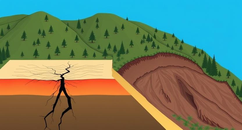
Geological Faults and Landslide Risk
Geological faults are fractures in the Earth’s crust where movement occurs along the fault plane. These fractures can play a significant role in increasing the risk of landslides in certain regions. When a fault line runs through an area prone to landslides, the movement along the fault can weaken the stability of the surrounding rock and soil, making it more susceptible to mass movement.
The presence of a fault line can also introduce additional stress into the ground, which can further destabilize slopes and trigger landslides. Additionally, the movement along a fault can create discontinuities in the rock layers, making it easier for water to infiltrate and saturate the soil, leading to an increased risk of landslides. In areas where geological faults intersect with steep slopes or areas of loose soil, the combination of factors can create a perfect storm for landslide activity.
• Geological faults are fractures in the Earth’s crust where movement occurs along the fault plane.
• Fault lines running through areas prone to landslides can weaken stability of surrounding rock and soil.
• Movement along a fault line can introduce additional stress into the ground, further destabilizing slopes.
• Fault movement can create discontinuities in rock layers, allowing water to infiltrate and saturate soil.
• Intersection of geological faults with steep slopes or loose soil can increase landslide risk.
How Groundwater Levels Affect Landslide Occurrence
Groundwater levels play a crucial role in the occurrence of landslides. When the groundwater saturates the soil or rock layers within a slope, it increases the overall weight of the materials, reducing the friction between them. This decrease in internal friction weakens the stability of the slope, making it more susceptible to movements such as slides or flows.
Additionally, high groundwater levels can also contribute to pore water pressure build-up within the slope material. As the pore water pressure increases, it further reduces the effective stress within the slope, making it easier for landslides to initiate. In areas where there is continuous or sudden infiltration of groundwater due to heavy rainfall, snowmelt, or other factors, the risk of landslides significantly escalates.
• Groundwater levels increase weight of materials within slope
• Decrease in internal friction weakens stability of slope
• High groundwater levels contribute to pore water pressure build-up within slope material
• Pore water pressure reduces effective stress within the slope, making landslides easier to initiate
• Continuous or sudden infiltration of groundwater due to heavy rainfall, snowmelt, or other factors escalates risk of landslides
The Importance of Geological Surveys in Identifying Landslide Prone Areas
Geological surveys play a crucial role in identifying areas prone to landslides. These surveys involve detailed assessments of the underlying rock formations, soil compositions, and topographical features of a region. By studying the geological characteristics of an area, experts can pinpoint potential landslide risk factors such as unstable rock formations, loose soil, or steep slopes that may increase the likelihood of mass movement.
Furthermore, geological surveys help in mapping out geological faults and fractures that can act as triggers for landslides. By understanding the geological structure of a region, scientists can predict how tectonic plate movements or seismic activity might influence landslide susceptibility. This information is vital for land use planning and disaster management strategies to minimize the impact of landslides on communities living in high-risk areas.
• Geological surveys involve detailed assessments of rock formations, soil compositions, and topographical features
• Experts can pinpoint potential landslide risk factors such as unstable rock formations, loose soil, or steep slopes
• Surveys help in mapping out geological faults and fractures that can act as triggers for landslides
• Understanding geological structure helps predict how tectonic plate movements or seismic activity might influence landslide susceptibility
• Information from surveys is vital for land use planning and disaster management strategies
The Role of Topography in Determining Landslide Risk
The topography of an area plays a crucial role in determining the risk of landslides. Steep slopes increase the likelihood of landslides due to gravitational pull on the rocks and soil. The angle of the slope directly affects the stability of the ground, with steeper slopes being more prone to failure and movement.
Additionally, the shape of the terrain can influence how water flows through the landscape. Concave slopes may collect and funnel water towards a specific point, increasing the chances of saturation and erosion leading to landslides. On the other hand, convex slopes may disperse water more evenly, reducing the risk of localized saturation and subsequent landslide activity.
• Steep slopes increase the likelihood of landslides due to gravitational pull on rocks and soil.
• The angle of the slope directly affects the stability of the ground, with steeper slopes being more prone to failure and movement.
• Concave slopes may collect and funnel water towards a specific point, increasing chances of saturation and erosion leading to landslides.
• Convex slopes may disperse water more evenly, reducing risk of localized saturation and subsequent landslide activity.
How Volcanic Activity Can Lead to Landslide Events
Volcanic activity can significantly increase the risk of landslide events in certain areas. The steep slopes created by volcanic eruptions, combined with the loose and fragmented nature of volcanic rocks and ash, make these regions particularly susceptible to landslides. The rapid deposition of volcanic materials can destabilize the surrounding terrain, leading to sudden and catastrophic landslide events that pose a significant threat to nearby communities and infrastructure.
In addition to the physical characteristics of volcanic deposits, the presence of water from rainfall or groundwater can further exacerbate landslide risks in volcanic regions. The interaction between water and volcanic materials can decrease friction between particles, reducing the stability of slopes and increasing the likelihood of landslides. As a result, areas affected by recent volcanic activity or located within volcanic landscapes should be closely monitored for signs of instability to help mitigate the potential impact of landslide events.
• Volcanic activity can create steep slopes that are prone to landslides
• Loose and fragmented volcanic rocks and ash increase landslide risk
• Rapid deposition of volcanic materials can destabilize terrain
• Presence of water from rainfall or groundwater can further increase landslide risks in volcanic regions
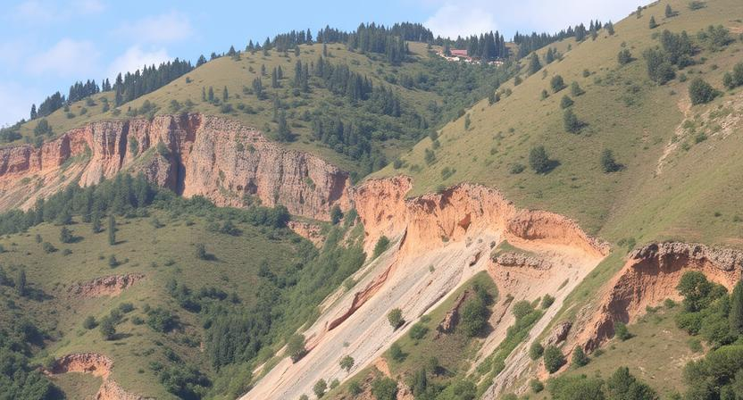
The Relationship Between Landslides and Erosion
Erosion and landslides are closely interconnected phenomena in the realm of geological processes. Erosion, the gradual wearing away of land surfaces through the action of wind, water, or ice, can significantly contribute to increasing the likelihood of landslides in vulnerable terrains. When erosion removes stabilizing elements like vegetation or alters the topography by wearing down slopes, the integrity of the landmass is compromised, making it more prone to slope failure and subsequent landslide events.
Moreover, erosion plays a crucial role in shaping landscapes and can exacerbate the impact of landslides by weakening the underlying rock and soil layers. Continuous erosion processes can undercut slopes, leading to instability and a higher risk of mass wasting events. The removal of material through erosion exposes fresh surfaces that are more susceptible to weathering and mechanical breakdown, which can trigger landslides in areas where erosion rates are high. Understanding the intricate relationship between erosion and landslides is essential for effective risk assessment and mitigation strategies in landslide-prone regions.
• Erosion and landslides are closely connected geological processes
• Erosion can increase the likelihood of landslides by removing stabilizing elements like vegetation
• Altering topography through erosion can compromise the integrity of landmasses, making them more prone to slope failure
• Continuous erosion weakens underlying rock and soil layers, exacerbating the impact of landslides
• High erosion rates can trigger landslides by exposing fresh surfaces susceptible to weathering
The Impact of Mining Activities on Landslide Occurrence
Mining activities can significantly increase the risk of landslides in certain areas due to the alteration of natural landscapes and soil composition. The excavation of minerals and resources can weaken the stability of slopes and rock formations, making them more susceptible to slope failures. The removal of large amounts of earth and vegetation during mining operations can also disrupt the natural drainage patterns, leading to increased water infiltration and saturation of the ground, further destabilizing the terrain.
Moreover, the construction of mining infrastructure such as access roads, tunnels, and tailings dams can alter the topography of an area, creating artificial slopes that may be prone to failure. The vibrations and blasting associated with mining activities can also induce stress on existing geological structures, potentially triggering landslides in nearby areas. It is crucial for mining companies to implement proper planning, monitoring, and mitigation measures to minimize the impacts of their operations on landslide occurrence and to ensure the safety of both the workers and the surrounding communities.
• Mining activities can weaken the stability of slopes and rock formations
• Removal of earth and vegetation disrupts natural drainage patterns
• Construction of mining infrastructure alters topography, creating artificial slopes
• Vibrations and blasting from mining activities induce stress on geological structures
Landslide Prediction Techniques Based on Geological Factors
Landslide prediction techniques based on geological factors are essential in mitigating the risks associated with these destructive natural events. One such technique involves conducting detailed geological surveys to identify areas prone to landslides. By studying the types of rock and soil composition present in an area, geologists can assess the stability of slopes and the likelihood of landslide occurrence. Additionally, analyzing the role of water saturation in soil, especially during periods of heavy rainfall or snowmelt, helps predict when conditions are ripe for landslides to occur.
Another effective technique for predicting landslides is assessing the impact of steep slopes on landslide susceptibility. Areas with steep topography are more prone to landslides due to gravitational forces acting on the unstable slopes. Geologists also consider the influence of earthquakes on landslide activity, as seismic events can trigger slope instability and rockfalls. By understanding these geological factors and their interactions, researchers can develop models to forecast landslide events and implement preventive measures in at-risk areas.
• Conducting detailed geological surveys to identify areas prone to landslides
• Studying types of rock and soil composition in an area
• Assessing stability of slopes and likelihood of landslide occurrence
• Analyzing water saturation in soil during heavy rainfall or snowmelt
• Assessing impact of steep slopes on landslide susceptibility
• Recognizing gravitational forces on unstable slopes
• Considering influence of earthquakes on landslide activity
• Developing models to forecast landslide events and implement preventive measures
Geological Indicators of Landslide Potential
An essential aspect of assessing landslide potential is to identify geological indicators that can signal areas at risk of slope failure. One key indicator is the type of rock and soil composition present in a particular region. Rocks that are highly fractured or weathered, as well as loose unconsolidated soil, are more prone to experiencing landslides due to reduced stability. Additionally, the presence of certain minerals that are prone to swelling or shrinking in response to water can increase the likelihood of slope instability.
Another significant geological indicator of landslide potential is the role of water saturation in the ground. Excessive water infiltration due to heavy rainfall or melting snow can significantly weaken the slope’s stability by reducing friction between grains of soil or rock particles. Areas with poor drainage or high groundwater levels are particularly vulnerable to landslides as the increased pore water pressure can decrease the shear strength of the slope materials. Understanding these geological indicators can help in identifying areas that are susceptible to landslide events and implementing appropriate mitigation strategies.
• Highly fractured or weathered rocks
• Loose unconsolidated soil
• Presence of minerals prone to swelling/shrinking in response to water
• Excessive water infiltration from heavy rainfall or melting snow
• Poor drainage/high groundwater levels
• Increased pore water pressure decreasing shear strength of slope materials
The Influence of Tectonic Plate Movement on Landslide Activity
Tectonic plate movement plays a significant role in influencing landslide activity in various regions around the world. When plates shift and interact, they can create immense pressure on the Earth’s crust, leading to the fracturing and weakening of rocks and soils. This increased stress on the land can result in the destabilization of slopes, making them more susceptible to landslides. In areas where tectonic plates converge or slide past each other, the likelihood of landslides occurring due to intense geological activity is heightened.
Additionally, the movement of tectonic plates can also alter the topography of a region, changing the orientation of slopes and impacting the distribution of stress within the Earth’s crust. These alterations in land structure can further contribute to the occurrence of landslides, especially in areas where the geological composition is already prone to mass movements. Understanding the influence of tectonic plate movement on landslide activity is essential for implementing effective mitigation strategies and ensuring the safety of communities living in landslide-prone regions.
• Tectonic plate movement creates pressure on the Earth’s crust
• Pressure can lead to fracturing and weakening of rocks and soils
• Destabilization of slopes can make them more susceptible to landslides
• Convergence or sliding past each other of plates increases likelihood of landslides
• Alterations in topography due to plate movement can impact distribution of stress
• Changes in land structure can contribute to occurrence of landslides
• Understanding influence is crucial for implementing mitigation strategies
• Safety of communities in landslide-prone areas relies on this understanding
The Role of Landslide History in Assessing Future Risk
Landslide history plays a crucial role in assessing future risk in vulnerable areas. By analyzing past landslide events, geologists can identify patterns and trends that help predict where future landslides are more likely to occur. This historical data provides valuable insights into the specific factors that contribute to landslide occurrence in certain locations.
Furthermore, understanding the history of landslides in an area allows researchers to assess changes in risk over time. By comparing past landslide activity with present conditions, such as changes in land use, vegetation cover, or climate patterns, experts can more accurately evaluate the current level of risk and anticipate potential landslide events in the future. This knowledge is essential for developing effective strategies to mitigate landslide risks and protect communities living in landslide-prone areas.
• Landslide history helps identify patterns and trends for predicting future events
• Historical data provides insights into factors contributing to landslide occurrence
• Comparing past landslide activity with present conditions allows for assessing changes in risk over time
• Understanding the history of landslides is essential for developing effective risk mitigation strategies
Effective Strategies for Mitigating Landslide Risks Based on Geological Factors
Mitigating landslide risks based on geological factors is crucial for ensuring the safety of communities living in landslide-prone areas. One effective strategy is implementing proper land use planning regulations that restrict construction in high-risk zones, such as steep slopes or areas with unstable rock and soil compositions. By understanding the geological factors that contribute to landslides, authorities can enforce building codes and regulations that help prevent human activities from triggering catastrophic events.
In addition to land use planning, improving slope stability through engineering solutions is another key strategy for mitigating landslide risks. Measures such as installing retaining walls, drainage systems, and slope reinforcements can help reduce the likelihood of slope failure and subsequent landslides. By considering the geological makeup of the area and implementing appropriate engineering measures, communities can better withstand the impact of natural disasters and minimize the potential devastation caused by landslides.
• Proper land use planning regulations can restrict construction in high-risk zones
• Understanding geological factors can help enforce building codes and regulations
• Improving slope stability through engineering solutions is crucial
• Installing retaining walls, drainage systems, and slope reinforcements can reduce likelihood of landslides
• Considering geological makeup of area when implementing engineering measures is important


