
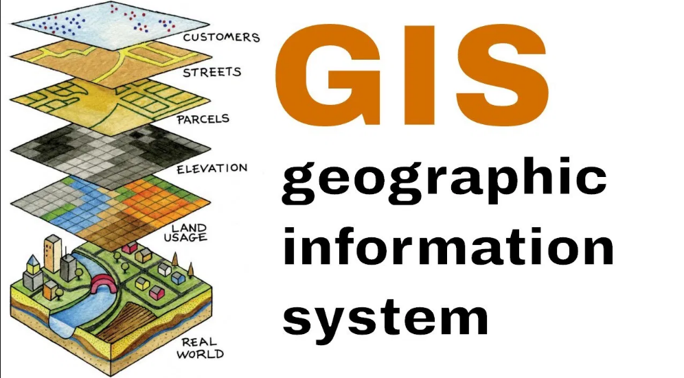
Definition of GIS
A Geographic Information System (GIS) is a powerful tool that allows users to capture, store, manipulate, analyze, manage, and present spatial or geographic data. By integrating various layers of information such as maps, charts, and statistics, GIS enables users to gain a deeper understanding of complex relationships and patterns within the data.
GIS technology plays a crucial role in visualizing data geographically, providing valuable insights that can support decision-making processes in a wide range of industries, from urban planning and environmental management to agriculture and health care. Its ability to overlay different datasets onto maps helps in identifying spatial trends and correlations, leading to informed and strategic planning initiatives.
• GIS allows users to capture, store, manipulate, analyze, manage, and present spatial or geographic data
• Integrates various layers of information such as maps, charts, and statistics
• Enables users to gain a deeper understanding of complex relationships and patterns within the data
• Plays a crucial role in visualizing data geographically
• Provides valuable insights that can support decision-making processes in various industries
History of GIS
GIS has a rich history that dates back to the early 1960s when the Canadian Geographer Roger Tomlinson is often credited with creating the first true GIS. Initially developed for land management, GIS technology rapidly evolved over the decades to encompass a wide range of applications across various industries.
During the 1970s and 1980s, advancements in computer technology and geographical information systems software led to the widespread adoption of GIS in governmental agencies, research institutions, and private companies. This period marked a significant turning point for GIS, as it transitioned from being a specialized tool for cartographers to a mainstream technology used for spatial analysis and decision-making in diverse fields.
• GIS has a rich history dating back to the early 1960s
• Canadian Geographer Roger Tomlinson is credited with creating the first true GIS
• Initially developed for land management, GIS technology rapidly evolved over the decades
• Advancements in computer technology and geographical information systems software led to widespread adoption of GIS in the 1970s and 1980s
• Transitioned from a specialized tool for cartographers to a mainstream technology used for spatial analysis and decision-making
Components of GIS
A Geographic Information System (GIS) comprises hardware, software, data, people, and methods that work collectively to capture, manage, analyze, and present spatial or geographical data. The primary components of GIS include input devices like GPS, output devices for visualizing data, software for data processing and analysis, databases to store and manage spatial information, and skilled professionals to interpret the results.
The hardware in GIS systems involves computers, tablets, GPS devices, printers, and scanners crucial for data collection, processing, and outputting. Software is essential in GIS for tasks like data input, mapping, spatial analysis, and visualization. Data forms the backbone of GIS, consisting of maps, satellite images, survey data, and attribute data that provide valuable insights for decision-making. Lastly, people, such as GIS analysts, technicians, and end-users, ensure the effective utilization of GIS tools and technology.
• A Geographic Information System (GIS) comprises hardware, software, data, people, and methods
• Input devices like GPS are essential for capturing spatial data
• Output devices such as printers are used to visualize data
• Software is crucial for processing and analyzing spatial information
• Databases store and manage spatial data efficiently
• Skilled professionals like GIS analysts interpret the results effectively
Types of GIS Data
GIS data can be classified into two main categories: spatial data and attribute data. Spatial data represents the geometric location and shape of geographic features such as points, lines, and polygons on the Earth’s surface. This type of data is crucial in GIS applications as it provides the framework for understanding the physical characteristics of a particular area. Attribute data, on the other hand, describes the characteristics or properties of the spatial features. It includes information such as the name, population, land use, and elevation of a specific location, adding depth and context to the spatial data.
Within these two broad categories, GIS data can further be classified as raster data and vector data. Raster data consists of a grid of cells or pixels, with each cell containing a value that represents a specific attribute such as temperature, elevation, or land cover. This type of data is commonly used in continuous phenomena analysis, such as temperature distribution mapping. Vector data, on the other hand, represents geographic features as discrete points, lines, and polygons. It is used to model and analyze discrete features, such as roads, rivers, and administrative boundaries, allowing for more precise spatial analysis and visualization in GIS applications.
• Spatial data represents the geometric location and shape of geographic features
• Attribute data describes the characteristics or properties of spatial features
• Raster data consists of a grid of cells with values representing attributes
• Vector data represents geographic features as discrete points, lines, and polygons
Applications of GIS in Urban Planning
Urban planning has been revolutionized by the integration of Geographic Information Systems (GIS) technology. This powerful tool allows city planners to efficiently collect, analyze, and visualize spatial data essential for making informed decisions. GIS aids in identifying suitable locations for infrastructure development, zoning regulations, and land use planning, leading to more sustainable and organized urban areas.
Furthermore, GIS enables urban planners to assess the impact of new projects on the existing environment and communities. By overlaying various datasets such as population density, transportation networks, and environmental factors, planners can simulate different scenarios and predict the outcomes of proposed changes. This informed approach helps in creating urban spaces that are not only functional but also harmonious with their surroundings.
• GIS technology allows city planners to efficiently collect, analyze, and visualize spatial data
• Helps in identifying suitable locations for infrastructure development and zoning regulations
• Assists in land use planning for more sustainable and organized urban areas
• Enables assessment of the impact of new projects on the existing environment and communities
• Allows simulation of different scenarios by overlaying various datasets such as population density, transportation networks, and environmental factors
GIS in Environmental Management
GIS plays a crucial role in monitoring and managing environmental resources. By integrating spatial data, GIS enables environmental managers to analyze and visualize complex relationships between different elements of the natural environment. This technology helps in identifying areas at risk, assessing the impact of human activities on ecosystems, and developing strategies for sustainable environmental management.
One of the key advantages of using GIS in environmental management is its ability to support decision-making processes based on accurate and up-to-date information. By mapping environmental features, such as water bodies, land use patterns, and vegetation cover, GIS provides valuable insights for addressing environmental challenges and planning conservation efforts effectively. This tool allows environmental managers to track changes in the environment over time, prioritize areas for conservation, and establish monitoring programs to ensure the long-term health of ecosystems.
• GIS enables environmental managers to analyze and visualize complex relationships between different elements of the natural environment
• It helps in identifying areas at risk and assessing the impact of human activities on ecosystems
• GIS aids in developing strategies for sustainable environmental management
• By mapping environmental features, such as water bodies, land use patterns, and vegetation cover, GIS provides valuable insights for addressing environmental challenges
• The technology allows for tracking changes in the environment over time and prioritizing areas for conservation efforts
GIS in Agriculture
GIS technology has revolutionized the agricultural sector by providing farmers with valuable insights to make informed decisions regarding crop management, soil quality, and irrigation practices. By analyzing spatial data such as land topography, soil properties, and weather patterns, GIS enables farmers to optimize their resources, increase crop yields, and minimize environmental impact. Through the integration of satellite imagery and GPS technology, farmers can precisely monitor and evaluate field conditions, leading to more efficient and sustainable agricultural practices.
Furthermore, GIS facilitates crop monitoring and disease management by creating detailed maps that identify areas of potential risk or crop stress. By overlaying information on pest outbreaks, soil nutrient levels, and weather conditions, farmers can quickly identify problem areas and implement targeted interventions to mitigate potential losses. Additionally, GIS plays a crucial role in inventory management, allowing farmers to track equipment, monitor crop growth, and streamline logistics for optimal harvest outcomes.
• GIS technology provides valuable insights for farmers to make informed decisions in crop management, soil quality, and irrigation practices
• Analysis of spatial data such as land topography, soil properties, and weather patterns helps optimize resources and increase crop yields
• Integration of satellite imagery and GPS technology allows precise monitoring and evaluation of field conditions for more efficient agricultural practices
• Detailed maps created by GIS aid in crop monitoring, disease management, and identification of areas at risk or under stress
• Overlaying information on pest outbreaks, soil nutrient levels, and weather conditions enables quick identification of problem areas for targeted interventions
• GIS plays a crucial role in inventory management by tracking equipment, monitoring crop growth, and streamlining logistics for optimal harvest outcomes.
GIS in Health Care
Geographic Information Systems (GIS) play a crucial role in revolutionizing the way health care services are delivered. By integrating spatial data with health information, GIS allows health care professionals to analyze patterns, trends, and relationships in disease spread, resource allocation, and accessibility to medical facilities. This spatial analysis helps in optimizing the planning and delivery of health care services, leading to improved patient outcomes and overall public health.
Additionally, GIS in health care enables the identification of high-risk areas for certain diseases, facilitating targeted interventions and preventive measures. Through the visualization of health data on maps, decision-makers can better understand the geographic distribution of health issues and make informed decisions to address them effectively. Overall, the use of GIS in health care not only enhances the efficiency of health service delivery but also contributes to the advancement of public health initiatives.
• GIS integrates spatial data with health information
• Allows analysis of patterns, trends, and relationships in disease spread
• Optimizes planning and delivery of health care services
• Identifies high-risk areas for certain diseases
• Facilitates targeted interventions and preventive measures
• Visualizes health data on maps for better decision-making
GIS in Transportation
GIS technology has revolutionized the way transportation systems are planned, managed, and optimized. By utilizing spatial data analysis, GIS provides valuable insights into traffic patterns, infrastructure planning, route optimization, and vehicle tracking. This enables transportation authorities to make informed decisions that improve efficiency, reduce congestion, and enhance overall user experience.
Moreover, GIS plays a crucial role in integrating various modes of transportation seamlessly. It enables the visual representation of different transportation networks, such as roads, railways, airways, and waterways, on a single platform. This integration facilitates better coordination between different transportation services, leading to enhanced connectivity, accessibility, and intermodal transportation solutions for both passengers and freight.
• GIS technology has revolutionized transportation systems
• Provides valuable insights into traffic patterns, infrastructure planning, route optimization, and vehicle tracking
• Enables informed decisions to improve efficiency and reduce congestion
• Integrates various modes of transportation seamlessly on a single platform
• Facilitates better coordination between different transportation services
GIS in Natural Resource Management
GIS plays a crucial role in the management of natural resources by providing tools for data collection, analysis, and visualization. Through GIS technology, researchers and decision-makers can map and monitor changes in land use, deforestation, water resources, and biodiversity, aiding in the conservation and sustainable use of natural resources. By integrating spatial data with other information, GIS helps in understanding complex relationships between different components of ecosystems, leading to more informed and effective resource management strategies.
Moreover, GIS enables the assessment of environmental impacts of human activities on natural resources by modeling scenarios and predicting future trends. This capability is particularly valuable in evaluating the consequences of various land management strategies, guiding policymakers in making informed decisions to balance conservation goals with socioeconomic development. Overall, the application of GIS in natural resource management enhances our capacity to protect and preserve the environment for future generations.
• GIS technology allows for data collection, analysis, and visualization in natural resource management
• Mapping and monitoring changes in land use, deforestation, water resources, and biodiversity is made easier with GIS
• Integration of spatial data with other information helps in understanding complex relationships within ecosystems
• GIS enables the assessment of environmental impacts of human activities on natural resources through scenario modeling
• Helps policymakers make informed decisions to balance conservation goals with socioeconomic development
GIS in Disaster Management
GIS plays a crucial role in disaster management by providing accurate mapping and analysis of the affected areas. Through the use of GIS technology, emergency responders can efficiently locate at-risk populations, identify evacuation routes, and coordinate rescue operations. GIS also helps in assessing the impact of disasters by mapping the extent of damage, evaluating infrastructure vulnerability, and planning for future mitigation efforts.
By integrating real-time data from various sources such as satellites, drones, and weather stations, GIS enables decision-makers to make informed choices during a crisis situation. The ability to overlay different layers of information on a map allows for better visualization of the disaster scenario, leading to more effective response strategies. Additionally, GIS aids in post-disaster recovery efforts by monitoring ongoing developments, tracking resources distribution, and facilitating communication among different agencies involved in the restoration process.
• GIS technology provides accurate mapping and analysis of affected areas
• Emergency responders can efficiently locate at-risk populations and identify evacuation routes
• GIS helps in assessing the impact of disasters by mapping damage extent and evaluating infrastructure vulnerability
• Real-time data integration from satellites, drones, and weather stations enables informed decision-making during crises
• Overlaying different layers of information on a map allows for better visualization of disaster scenarios
• GIS aids in post-disaster recovery efforts by monitoring ongoing developments, tracking resource distribution, and facilitating communication among agencies
GIS in Public Safety
Public safety agencies have increasingly turned to Geographic Information Systems (GIS) to enhance their capabilities in emergency response and crime prevention. GIS technology allows these agencies to analyze and visualize spatial data, aiding in the identification of high-risk areas and efficient allocation of resources. By integrating various data sources such as crime statistics, population density, and infrastructure maps, GIS helps public safety officials make informed decisions and respond promptly to incidents.
Moreover, GIS plays a crucial role in incident management and disaster response by providing real-time information on the location of emergency services, evacuation routes, and critical infrastructure. This spatial intelligence enables first responders to navigate through complex environments, assess the impact of disasters, and coordinate rescue efforts effectively. Through the power of GIS, public safety agencies are better equipped to mitigate risks, safeguard communities, and ensure a swift and coordinated response to emergencies.
• GIS technology allows public safety agencies to analyze and visualize spatial data
• Integration of various data sources such as crime statistics, population density, and infrastructure maps
• Helps in identifying high-risk areas and efficient allocation of resources
• Enables informed decision-making and prompt response to incidents
• GIS plays a crucial role in incident management and disaster response
• Provides real-time information on the location of emergency services, evacuation routes, and critical infrastructure
• Spatial intelligence helps first responders navigate complex environments and coordinate rescue efforts effectively
• Equips public safety agencies to mitigate risks, safeguard communities, and ensure a coordinated response to emergencies
GIS in Business
The utilization of Geographic Information Systems (GIS) in business has significantly revolutionized the way organizations analyze and interpret spatial data. By incorporating GIS technology into their operations, businesses can gain valuable insights into market trends, consumer behavior, and competitive landscapes. This spatial analysis enables companies to make informed decisions related to site selection, marketing strategies, and resource allocation, ultimately leading to improved efficiency and profitability.
Furthermore, GIS facilitates businesses in visualizing their data through interactive maps, allowing for better communication of complex information and enhanced decision-making processes. This visual representation of data helps businesses identify patterns and correlations that may not be apparent through traditional data analysis methods. By leveraging GIS tools, businesses can gain a competitive advantage by optimizing operations, targeting specific customer segments, and identifying new market opportunities with greater precision and accuracy.
• GIS technology revolutionizes how organizations analyze spatial data
• Businesses can gain insights into market trends, consumer behavior, and competitive landscapes
• Spatial analysis helps in informed decisions related to site selection, marketing strategies, and resource allocation
Furthermore, GIS enables businesses to visualize their data through interactive maps. This visualization allows for better communication of complex information and enhances decision-making processes. The visual representation of data helps identify patterns and correlations that may not be apparent through traditional analysis methods. By leveraging GIS tools, businesses can optimize operations, target specific customer segments, and identify new market opportunities with greater precision and accuracy.
In conclusion, the integration of Geographic Information Systems (GIS) in business operations has proven to be a game-changer for companies looking to stay ahead in today’s competitive landscape. By harnessing the power of spatial analysis and visualization tools offered by GIS technology, businesses can make more informed decisions leading to improved efficiency and profitability. With the ability to gain valuable insights into market trends and consumer behavior while identifying new opportunities for growth, it is clear that GIS is a vital tool for any modern business looking to succeed in an increasingly data-driven world.
GIS in Archaeology
GIS technology has revolutionized the field of archaeology, providing researchers with powerful tools to analyze and visualize spatial data. By integrating data from excavations, surveys, and remote sensing technologies, GIS enables archaeologists to map out ancient sites, analyze patterns of human settlement, and gain insights into past civilizations. This geo-referencing capability allows archaeologists to understand the spatial relationships between artifacts, structures, and landscapes, leading to a more comprehensive understanding of past human activities.
Furthermore, GIS plays a crucial role in cultural heritage management by helping archaeologists monitor and protect archaeological sites from threats such as urban development, looting, and environmental degradation. By creating detailed digital maps of archaeological sites and their surrounding areas, GIS allows researchers to assess site vulnerability, plan conservation strategies, and make informed decisions regarding site preservation. This proactive approach facilitated by GIS technology helps safeguard our cultural heritage for future generations to study and appreciate.
• GIS technology has revolutionized the field of archaeology
• Integrates data from excavations, surveys, and remote sensing technologies
• Allows mapping out ancient sites and analyzing patterns of human settlement
• Helps gain insights into past civilizations through spatial data analysis
• Crucial role in cultural heritage management
• Monitors and protects archaeological sites from threats such as urban development and looting
• Creates detailed digital maps for assessing site vulnerability and planning conservation strategies
• Facilitates informed decisions regarding site preservation to safeguard cultural heritage
GIS in Sociology
Sociology has greatly benefited from the integration of Geographic Information Systems (GIS) in its research methodologies. GIS allows sociologists to analyze spatial patterns and relationships within society, providing valuable insights into social phenomena and human behaviors. By mapping and visualizing social data such as demographic information, income distribution, and community structures, researchers can better understand how various factors intersect and influence social dynamics.
The use of GIS in sociology has revolutionized the way researchers study issues such as urban segregation, population migration, and social inequality. Through spatial analysis and mapping, sociologists can identify patterns of social exclusion, assess the impact of policies on different communities, and explore the spatial dimensions of social interactions. GIS not only enhances the visualization of sociological data but also facilitates the integration of multiple data sources, allowing researchers to conduct more comprehensive and nuanced analyses of complex social issues.
• GIS allows sociologists to analyze spatial patterns and relationships within society
• Provides valuable insights into social phenomena and human behaviors
• Mapping and visualizing social data such as demographic information, income distribution, and community structures
• Revolutionized the study of urban segregation, population migration, and social inequality
• Identifying patterns of social exclusion through spatial analysis and mapping
• Assessing the impact of policies on different communities
• Exploring the spatial dimensions of social interactions
• Enhances visualization of sociological data
• Facilitates integration of multiple data sources for comprehensive analyses
GIS in Geology
Understanding the Earth’s composition and structure is crucial in the field of geology. GIS technology plays a vital role in geology by allowing geologists to analyze various spatial data related to rocks, minerals, fault lines, and other geological features. By integrating different layers of information, geologists can create detailed maps and models that provide valuable insights into the Earth’s processes and history.
One of the key applications of GIS in geology is in mineral exploration and resource management. By using GIS tools, geologists can identify potential mineral deposits, assess their economic viability, and plan efficient extraction strategies. This technology also helps in monitoring environmental impacts of mining activities and making informed decisions for sustainable resource utilization.
• GIS technology allows geologists to analyze spatial data related to rocks, minerals, fault lines, and other geological features
• Integration of different layers of information helps in creating detailed maps and models for insights into Earth’s processes
• GIS is crucial in mineral exploration for identifying potential deposits, assessing economic viability, and planning extraction strategies
• Helps in monitoring environmental impacts of mining activities and making decisions for sustainable resource utilization
GIS in Climate Change Studies
In the realm of climate change studies, GIS serves as a pivotal tool for understanding and analyzing the complex interactions between various environmental factors. By integrating spatial data on temperature changes, precipitation patterns, and greenhouse gas emissions, GIS enables researchers to create detailed models that can forecast the potential impacts of climate change on different regions. This information is crucial for policymakers and scientists seeking to develop effective mitigation and adaptation strategies to address the challenges posed by global warming.
Moreover, GIS plays a crucial role in monitoring the natural habitats and ecosystems that are most vulnerable to the effects of climate change. By mapping changes in land cover, sea levels, and biodiversity, GIS helps conservationists identify areas that require special attention and protection. This allows for the implementation of targeted conservation efforts aimed at preserving the ecological balance in the face of changing climatic conditions.
• GIS integrates spatial data on temperature changes, precipitation patterns, and greenhouse gas emissions
• Detailed models can be created to forecast potential impacts of climate change on different regions
• Crucial information for policymakers and scientists developing mitigation and adaptation strategies
• GIS monitors natural habitats and ecosystems vulnerable to climate change effects
• Maps changes in land cover, sea levels, and biodiversity
• Helps conservationists identify areas needing special attention and protection
Challenges in GIS Implementation
GIS implementation comes with its fair share of challenges that organizations need to address for successful deployment. One such obstacle is the high cost associated with setting up and maintaining GIS systems, including software, hardware, and skilled personnel. Acquiring and updating geographical data can also be an expensive and time-consuming process, making it crucial for businesses and government agencies to carefully allocate resources for GIS projects.
Another significant challenge in GIS implementation is the need for inter-departmental collaboration and data sharing within an organization. Different departments may use varied data formats or maintain separate databases, leading to compatibility issues that hinder the smooth functioning of GIS systems. Additionally, ensuring data accuracy, quality, and security poses a continuous challenge for GIS professionals, as the integrity of information is fundamental to the effectiveness of spatial analysis and decision-making processes.
• High cost associated with setting up and maintaining GIS systems
• Acquiring and updating geographical data can be expensive and time-consuming
• Need for inter-departmental collaboration and data sharing within an organization
• Compatibility issues due to varied data formats or separate databases maintained by different departments
• Ensuring data accuracy, quality, and security poses a continuous challenge
Future Trends in GIS
As technology continues to advance rapidly, the future of Geographic Information Systems (GIS) holds exciting possibilities. One of the key trends expected to shape the GIS landscape is the increasing integration of artificial intelligence and machine learning algorithms. These technologies will enable GIS systems to analyze and interpret complex spatial data more efficiently, unlocking new insights and improving decision-making processes in various industries.
Another emerging trend in GIS is the growing emphasis on enhancing user experience through the development of more intuitive interfaces and interactive visualization tools. User-friendly interfaces will make GIS applications more accessible to a wider range of users, empowering them to harness the power of spatial data in their workflows with greater ease and efficiency. Additionally, the integration of real-time data streams and sensor networks is poised to revolutionize GIS applications, enabling users to access dynamic, up-to-date information for more accurate analysis and decision-making.
• The increasing integration of artificial intelligence and machine learning algorithms in GIS systems
• Enhancing user experience through more intuitive interfaces and interactive visualization tools
• Integration of real-time data streams and sensor networks to revolutionize GIS applications
As we reflect on the diverse applications and significant impact of Geographic Information Systems (GIS) across various sectors, it becomes apparent that GIS has become an indispensable tool in today’s world. From urban planning to disaster management, agriculture to health care, GIS has revolutionized the way data is analyzed, interpreted, and utilized to make informed decisions. The versatility and effectiveness of GIS technology continue to shape our understanding and management of the environment, resources, and societal challenges.
Looking ahead, the future of GIS appears promising, with ongoing advancements in technology driving innovation and expanding the horizons of spatial analysis and visualization. As we navigate the complexities of a rapidly changing world, GIS will play a crucial role in addressing emerging challenges and opportunities across different domains. By harnessing the power of GIS, we can continue to explore new frontiers, enhance decision-making processes, and create sustainable solutions for a better tomorrow.
• As we reflect on the diverse applications and significant impact of Geographic Information Systems (GIS) across various sectors, it becomes apparent that GIS has become an indispensable tool in today’s world.
• From urban planning to disaster management, agriculture to health care, GIS has revolutionized the way data is analyzed, interpreted, and utilized to make informed decisions.
• The versatility and effectiveness of GIS technology continue to shape our understanding and management of the environment, resources, and societal challenges.
• Looking ahead, the future of GIS appears promising, with ongoing advancements in technology driving innovation and expanding the horizons of spatial analysis and visualization.
• As we navigate the complexities of a rapidly changing world, GIS will play a crucial role in addressing emerging challenges and opportunities across different domains.
• By harnessing the power of GIS, we can continue to explore new frontiers, enhance decision-making processes, and create sustainable solutions for a better tomorrow.


