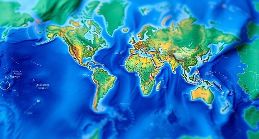
The Importance of Cartography in Shaping Perspectives
Maps are not just tools for navigation; they play a crucial role in shaping how we see the world around us. By visually representing geographical features and boundaries, cartography has the power to influence our perceptions and understanding of different regions, cultures, and environments. The way in which maps are drawn, labeled, and colored can convey certain biases or perspectives, emphasizing or neglecting specific information that can influence how individuals interpret and interact with the world.
Throughout history, maps have been used to assert power, claim territories, and define boundaries. The visual representation of land and resources on maps has been instrumental in shaping political, economic, and social structures. By highlighting certain areas or omitting others, maps can perpetuate existing power dynamics or challenge traditional narratives, making them powerful tools for studying the complexities of human society and the natural environment.
• Maps visually represent geographical features and boundaries
• Cartography influences perceptions and understanding of regions, cultures, and environments
• The way maps are drawn can convey biases or perspectives
• Maps have been used throughout history to assert power, claim territories, and define boundaries
• Maps shape political, economic, and social structures by highlighting certain areas or omitting others
Early Maps and Their Influence on Exploration
Early maps played a crucial role in shaping the trajectory of exploration during ancient times. These early cartographic representations not only provided navigators with a sense of direction but also fueled their ambitions to discover new lands and expand their understanding of the world beyond familiar territories. As explorers set out on perilous voyages across oceans and continents, the maps they carried became indispensable tools guiding their journeys and helping them navigate uncharted waters.
The influence of early maps on exploration extended beyond mere navigation, as they often held symbolic significance, representing political power and conquest. By asserting territorial claims through mapping, nations solidified their hegemony over newly discovered lands and established themselves as formidable players on the global stage. These maps not only guided exploration but also served as propaganda tools, glorifying the achievements of explorers and shaping public perceptions of distant lands and peoples.
• Early maps provided navigators with a sense of direction
• Maps fueled ambitions to discover new lands and expand understanding of the world
• Cartographic representations guided explorers on perilous voyages across oceans and continents
• Maps held symbolic significance, representing political power and conquest
• Nations asserted territorial claims through mapping to solidify hegemony over newly discovered lands
• Maps served as propaganda tools, glorifying achievements of explorers and shaping public perceptions
The Evolution of Mapping Techniques
Mapping techniques have significantly evolved over the centuries, from early rudimentary drawings on cave walls to highly sophisticated digital maps used today. The use of precise measurements, advanced surveying tools, and satellite imagery has revolutionized the way we create maps, allowing for more accurate and detailed representations of the world around us.
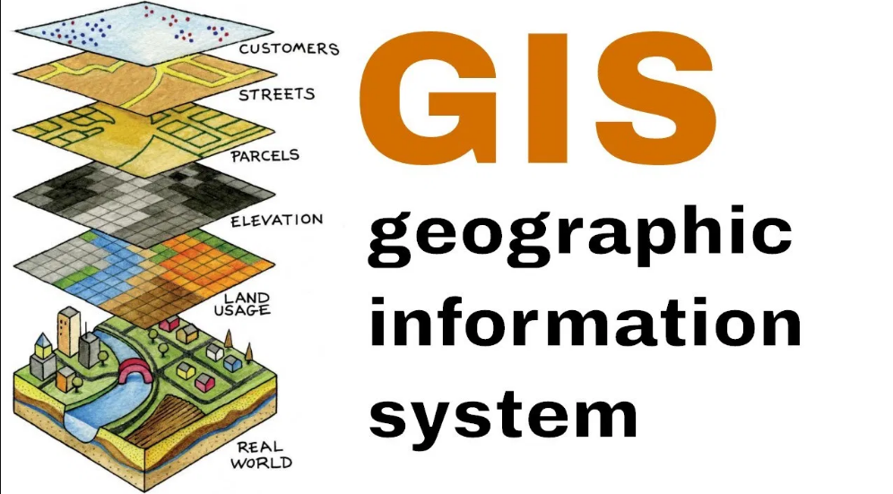
Advancements in technology, such as Geographic Information Systems (GIS) and remote sensing, have enabled cartographers to gather, analyze, and visualize vast amounts of data to create comprehensive and dynamic maps. These modern techniques not only enhance the accuracy of maps but also provide valuable insights into various fields like urban planning, environmental conservation, and disaster response.
• Mapping techniques have evolved from cave drawings to digital maps
• Precise measurements and advanced surveying tools have revolutionized map creation
• Satellite imagery allows for more accurate and detailed representations of the world
• Geographic Information Systems (GIS) and remote sensing enable cartographers to gather, analyze, and visualize vast amounts of data
• Modern mapping techniques provide valuable insights into fields like urban planning, environmental conservation, and disaster response
The Role of Maps in Defining National Borders
Maps have played a significant role in defining national borders throughout history. By visually delineating territories and boundaries, maps have served as important tools for governments and policymakers to establish and reinforce their claims to specific regions. The accuracy and precision of maps have been crucial in avoiding disputes and conflicts between neighboring countries, providing a clear representation of each nation’s recognized borders.
Moreover, maps have been utilized as diplomatic instruments in negotiating border agreements and treaties between nations. The visual clarity offered by maps has allowed for more transparent and efficient discussions regarding territorial disputes and boundary delineations. As a result, maps have not only helped in defining national borders but have also contributed to fostering peaceful relations and cooperation between countries through the clear demarcation of their respective territories.
• Maps visually delineate territories and boundaries
• Important tools for governments and policymakers to establish claims to specific regions
• Accuracy and precision crucial in avoiding disputes between neighboring countries
Furthermore, maps have also been used as educational tools to help citizens understand the geography of their country and its borders. By studying maps, individuals can gain a better appreciation of the physical layout of their nation and how it relates to neighboring countries. This knowledge can foster a sense of national identity and pride among citizens, as they develop a deeper understanding of the land that they call home.
In addition, maps have played a role in shaping historical events by influencing decisions made by leaders regarding territorial expansion or contraction. The visual representation provided by maps has often guided political strategies and military campaigns aimed at altering national borders. As such, maps have not only defined national borders but have also influenced the course of history through their depiction of geographical boundaries.
• Maps used as educational tools for citizens to understand geography
• Foster sense of national identity and pride among citizens
• Influence decisions made by leaders regarding territorial expansion or contraction
The Impact of Maps on Trade and Commerce
Trade and commerce have always been intricately linked with the use of maps. From ancient trade routes marked on parchments to modern digital mapping systems, maps play a crucial role in facilitating the movement of goods and services across various regions. Accurate maps enable merchants and traders to plan their routes efficiently, navigate through unfamiliar territories, and identify key market centers.
Maps also help businesses make informed decisions by providing valuable insights into geographical factors that can impact trade, such as terrain, climate, and proximity to resources. In addition, maps showcasing trade routes and shipping lanes assist in optimizing logistical operations, reducing transportation costs, and ultimately enhancing the efficiency of global supply chains. As a result, maps serve as essential tools for businesses looking to expand their market reach, establish new trade relationships, and capitalize on emerging commercial opportunities.
– Maps help merchants and traders plan routes efficiently
– Maps enable navigation through unfamiliar territories
– Maps identify key market centers for trade
– Maps provide insights into geographical factors affecting trade like terrain and climate
– Trade route maps optimize logistical operations
– Shipping lane maps reduce transportation costs
– Maps enhance the efficiency of global supply chains
– Essential tools for businesses to expand market reach
Maps as Tools for Military Strategy
Maps play a crucial role in military strategy by providing essential information for planning and executing operations. Military commanders rely on maps to understand terrain features, enemy positions, and logistical routes. By using detailed maps, strategists can identify key locations for troop deployment, navigate challenging landscapes, and anticipate potential obstacles during campaigns. The accuracy and thoroughness of maps are instrumental in ensuring the success and effectiveness of military missions.
Furthermore, maps aid in coordinating movements and communications among different units within a military operation. By referencing maps, troops can synchronize their actions, maintain situational awareness, and respond promptly to changing circumstances on the battlefield. Effective use of maps enables military forces to adapt their strategies, exploit enemy weaknesses, and achieve tactical objectives with precision and coordination.
• Maps provide essential information for planning and executing military operations
• Military commanders rely on maps to understand terrain features, enemy positions, and logistical routes
• Detailed maps help identify key locations for troop deployment and anticipate potential obstacles during campaigns
• Accuracy and thoroughness of maps are crucial for the success and effectiveness of military missions
Furthermore, maps play a vital role in coordinating movements and communications among different units within a military operation. Troops can reference maps to synchronize their actions, maintain situational awareness, and respond promptly to changing circumstances on the battlefield. Effective use of maps allows military forces to adapt their strategies, exploit enemy weaknesses, and achieve tactical objectives with precision and coordination.
Overall, maps serve as indispensable tools for military strategy by providing critical information that guides decision-making processes at all levels of command. Whether used for strategic planning or tactical maneuvering, maps enhance operational efficiency, increase situational awareness, and contribute to mission success in complex combat environments.
How Maps Have Helped in Disaster Response and Relief Efforts
In times of disasters, maps play a pivotal role in aiding response and relief efforts. From hurricanes to earthquakes, having accurate and up-to-date maps can be the key to effectively coordinating emergency response teams and resources. Maps not only provide a visual representation of affected areas but also help in identifying critical infrastructure, potential hazards, and access points for delivering aid.
Furthermore, the integration of Geographic Information Systems (GIS) technology has revolutionized disaster response and relief efforts. By layering real-time data onto maps, responders can analyze dynamic situations, track the movement of the disaster, and allocate resources strategically. GIS mapping allows for quick decision-making, enhanced situational awareness, and improved coordination between various agencies involved in the relief operations.
• Maps provide a visual representation of affected areas
• Maps help in identifying critical infrastructure and potential hazards
• Maps assist in locating access points for delivering aid
• GIS technology allows for layering real-time data onto maps
• GIS mapping enables quick decision-making during disasters
• GIS technology enhances situational awareness for responders
• Improved coordination between relief agencies through GIS mapping
The Influence of Maps on Cultural and Social Identities
Maps play a crucial role in shaping cultural and social identities by illustrating the boundaries of nations and regions. They not only delineate physical spaces but also define the collective identity of a group of people inhabiting a specific area. The depiction of territories and landmarks on maps contributes to a sense of belonging and connection to a particular culture or society.
Furthermore, maps can reflect the cultural values and historical narratives of a community through the way they portray certain regions or landmarks. Different symbols, colors, and labels on maps can highlight significant cultural sites, heritage, or events that are considered integral to the identity of a group of people. By visually representing these elements, maps serve as powerful tools in reinforcing and preserving cultural heritage and social identities.
• Maps illustrate the boundaries of nations and regions, shaping cultural and social identities
• They define the collective identity of people inhabiting a specific area
• Depiction of territories and landmarks on maps contributes to a sense of belonging and connection to a particular culture or society
• Different symbols, colors, and labels on maps highlight significant cultural sites, heritage, or events
• Maps reflect cultural values and historical narratives of communities through their portrayal of certain regions or landmarks.
Maps and the Spread of Ideas and Knowledge
Maps have long been essential tools in the dissemination of ideas and knowledge throughout history. They have played a crucial role in facilitating trade, exploration, and the exchange of cultural and scientific information. By visually representing spatial relationships and connections between different regions, maps have helped to bridge geographical gaps and foster communication between diverse communities.
Moreover, maps have not only served as practical navigational tools but have also been powerful symbols of power and influence. Through the strategic dissemination of maps, empires and nations have been able to assert their authority and extend their reach across vast territories. As maps continue to evolve with advancements in technology, their role in shaping our understanding of the world and influencing the spread of ideas will undoubtedly persist into the future.
• Maps have been essential tools in disseminating ideas and knowledge throughout history
• They facilitate trade, exploration, and the exchange of cultural and scientific information
• Maps visually represent spatial relationships and connections between regions
• They bridge geographical gaps and foster communication between diverse communities
Moreover, maps have not only served as practical navigational tools but have also been powerful symbols of power and influence. Through the strategic dissemination of maps, empires and nations have been able to assert their authority and extend their reach across vast territories. As maps continue to evolve with advancements in technology, their role in shaping our understanding of the world and influencing the spread of ideas will undoubtedly persist into the future.
The Use of Mapping Technology in Modern Cartography
In modern cartography, mapping technology plays a pivotal role in creating accurate and detailed maps that are essential for various purposes. The advent of Geographic Information Systems (GIS) has revolutionized the way maps are produced, allowing for the integration of vast amounts of spatial data to generate highly informative visual representations of geographical features. This technology enables cartographers to capture, store, analyze, and present geographic information in a more efficient and dynamic manner, leading to the creation of sophisticated maps that cater to diverse needs and applications.
Furthermore, the use of remote sensing technologies like satellite imagery and aerial photography has significantly enhanced the precision and scope of modern cartography. These advanced tools provide cartographers with the capability to capture detailed information about the Earth’s surface from a distance, allowing for the production of maps with unparalleled accuracy and resolution. By harnessing the power of mapping technology, cartographers can now create maps that not only accurately depict physical landscapes but also incorporate real-time data, enabling decision-makers to make informed choices based on the latest spatial information available.
• Mapping technology, particularly Geographic Information Systems (GIS), is crucial for creating accurate and detailed maps
• GIS allows for the integration of vast amounts of spatial data to generate informative visual representations of geographical features
• Remote sensing technologies like satellite imagery and aerial photography enhance the precision and scope of modern cartography
• These advanced tools provide detailed information about the Earth’s surface from a distance, resulting in maps with unparalleled accuracy and resolution
• By utilizing mapping technology, cartographers can create maps that incorporate real-time data for informed decision-making
The Accessibility of Maps in the Digital Age
The digital age has revolutionized the way we access and interact with maps. With the widespread availability of mapping applications and platforms on various devices, accessing maps has never been easier. People can now quickly navigate through digital maps to explore different locations, plan their routes, and gather information with just a few taps or clicks.
The accessibility of maps in the digital age has also opened up new possibilities for collaboration and data sharing. Through online mapping tools and platforms, individuals and organizations can create and customize maps, share geospatial data, and collaborate on projects regardless of their physical location. This digital interconnectedness has facilitated the rapid exchange of information, enabling more efficient decision-making processes and fostering innovation in various fields.
• The digital age has revolutionized the way we access and interact with maps.
• With mapping applications on various devices, accessing maps has never been easier.
• People can quickly navigate through digital maps to explore different locations and plan routes.
• Online mapping tools allow for collaboration and data sharing regardless of physical location.
• Individuals and organizations can create, customize, and share geospatial data easily.
• Digital interconnectedness enables rapid exchange of information for more efficient decision-making processes.
The Ethical Considerations of Mapmaking
When creating maps, cartographers must consider the ethical implications of their work. One crucial aspect is ensuring accuracy and transparency in representing geographical features and boundaries. Misleading representations can have serious consequences, from fueling territorial disputes to impacting the rights and identities of communities. Additionally, respecting cultural sensitivities and land rights is essential in mapmaking. Indigenous knowledge and place names should be acknowledged and incorporated to avoid erasure and appropriation.
Another ethical consideration in mapmaking is the responsible use of data and technology. Cartographers must prioritize privacy and security when collecting, storing, and sharing sensitive information. Ensuring that data is up-to-date and reliable helps prevent misinformation and promotes informed decision-making. Moreover, considering the environmental impact of mapping activities, such as deforestation for paper maps or energy consumption in digital mapping, is crucial for sustainable cartographic practices.
• Accuracy and transparency are crucial in representing geographical features and boundaries
• Misleading representations can fuel territorial disputes and impact communities
• Respecting cultural sensitivities and land rights is essential in mapmaking
• Indigenous knowledge and place names should be acknowledged to avoid erasure and appropriation
• Responsible use of data and technology is an ethical consideration in mapmaking
• Prioritizing privacy and security when collecting, storing, sharing sensitive information is important
• Up-to-date, reliable data helps prevent misinformation and promotes informed decision-making
• Considering the environmental impact of mapping activities is crucial for sustainable cartographic practices
Maps and Environmental Conservation Efforts
In the realm of environmental conservation efforts, maps serve as invaluable tools for understanding and protecting the Earth’s ecosystems. By providing visual representations of landscapes, biodiversity hotspots, and natural resources, maps enable conservationists to identify key areas for preservation and sustainable use. Through detailed mapping techniques, researchers can track changes in land use, deforestation rates, and habitat fragmentation, aiding in the development of effective conservation strategies.
Additionally, maps play a crucial role in facilitating collaboration among stakeholders involved in environmental conservation projects. By creating shared spatial datasets and interactive mapping platforms, organizations can streamline communication, coordinate efforts, and monitor progress towards conservation goals. This interconnected approach, bolstered by the power of cartography, enhances decision-making processes and fosters a more cohesive and efficient approach to protecting our planet’s precious natural resources.
• Maps provide visual representations of landscapes, biodiversity hotspots, and natural resources
• Helps conservationists identify key areas for preservation and sustainable use
• Tracking changes in land use, deforestation rates, and habitat fragmentation through mapping techniques
• Facilitates collaboration among stakeholders involved in environmental conservation projects
• Creating shared spatial datasets and interactive mapping platforms to streamline communication
• Coordinate efforts and monitor progress towards conservation goals
• Enhances decision-making processes and fosters a more cohesive approach to protecting natural resources
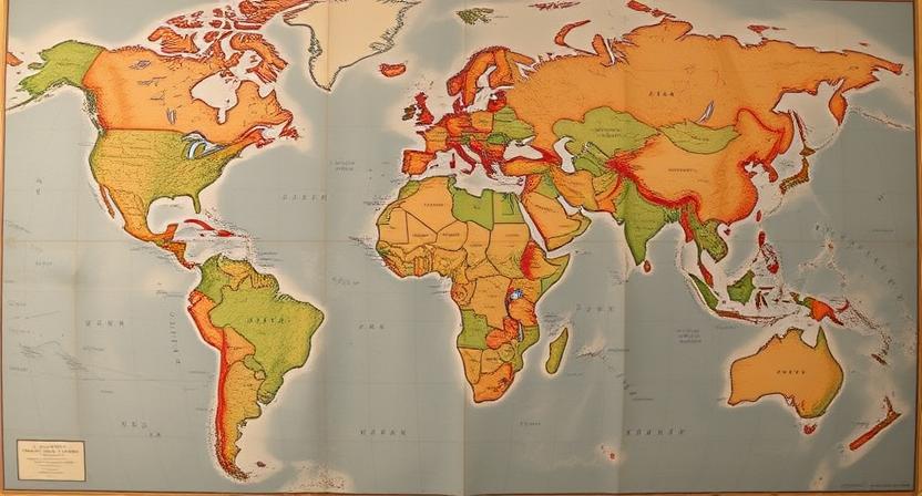
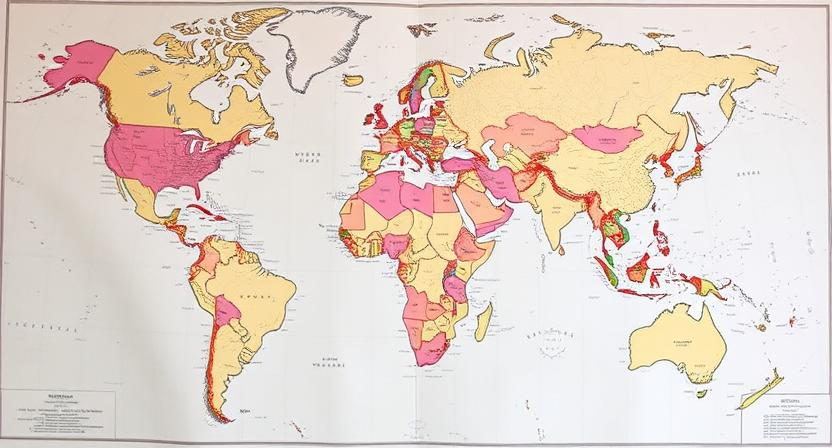
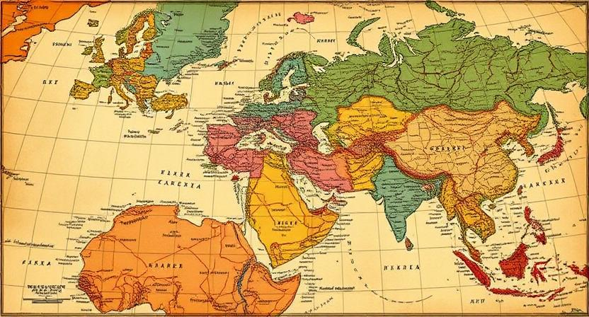
The Influence of Colonialism on Mapmaking
During the era of colonialism, mapmaking played a crucial role in the expansion and consolidation of colonial empires. European powers relied heavily on maps to claim territories, define boundaries, and assert control over newly acquired lands. Maps were not only used as tools for navigation and exploration but also as instruments of political power and domination. Colonial mapmakers often distorted geographical realities to justify territorial conquests and reinforce colonial authority. These biased representations not only reflected but also perpetuated unequal power dynamics between colonizers and indigenous populations.
Colonial mapmaking also served as a means of othering and exoticizing indigenous peoples. Indigenous territories were often inaccurately represented or completely omitted from colonial maps, reinforcing the myth of terra nullius or empty lands that justified European colonization. This deliberate erasure of indigenous presence and knowledge not only marginalized indigenous communities but also legitimized the dispossession of their lands and resources. The legacy of colonial mapmaking continues to shape contemporary geopolitical boundaries and socio-economic disparities in many parts of the world.
• Colonial mapmaking was crucial for the expansion and consolidation of colonial empires
• European powers used maps to claim territories, define boundaries, and assert control over newly acquired lands
• Maps were not only tools for navigation but also instruments of political power and domination
• Biased representations in colonial maps justified territorial conquests and reinforced colonial authority
Colonial mapmaking played a role in othering and exoticizing indigenous peoples
Indigenous territories were inaccurately represented or omitted from colonial maps
This reinforced the myth of terra nullius, justifying European colonization
The deliberate erasure marginalized indigenous communities and legitimized dispossession of their lands
The legacy of colonial mapmaking continues to influence contemporary geopolitical boundaries
Socio-economic disparities in many parts of the world can be traced back to colonial era mapping efforts
The Role of Maps in Urban Planning and Development
Maps play a crucial role in urban planning and development by providing valuable spatial information to city planners and policymakers. These maps serve as visual tools that display various aspects of a city such as land use, infrastructure, transportation networks, and demographics. By analyzing and interpreting the data depicted on these maps, urban planners can make informed decisions regarding future development projects, zoning regulations, and public services allocation.
Through the use of Geographic Information Systems (GIS), maps in urban planning have become even more powerful and versatile. GIS technology allows city planners to overlay different layers of information on maps, enabling them to identify patterns, trends, and relationships that may not be immediately apparent. This detailed spatial analysis helps in creating sustainable urban environments, improving transportation systems, managing natural resources, and enhancing overall quality of life for residents. By utilizing maps and GIS in urban planning, cities can better address the challenges of rapid urbanization and strive towards creating more efficient, inclusive, and resilient urban spaces.
• Maps provide valuable spatial information for city planners and policymakers
• Display various aspects of a city such as land use, infrastructure, transportation networks, and demographics
• Aid in making informed decisions regarding future development projects, zoning regulations, and public services allocation
Through the use of Geographic Information Systems (GIS), maps in urban planning have become even more powerful and versatile. GIS technology allows city planners to overlay different layers of information on maps, enabling them to identify patterns, trends, and relationships that may not be immediately apparent. This detailed spatial analysis helps in creating sustainable urban environments, improving transportation systems, managing natural resources, and enhancing overall quality of life for residents. By utilizing maps and GIS in urban planning cities can better address the challenges of rapid urbanization and strive towards creating more efficient inclusive resilient urban spaces.
• GIS technology enables overlaying different layers of information on maps
• Helps identify patterns trends relationships not immediately apparent
• Creates sustainable urban environments improves transportation systems manages natural resources enhances quality of life for residents
How Maps Have Helped in Wildlife Conservation
Maps have played a crucial role in wildlife conservation efforts by providing valuable spatial information and aiding in effective decision-making. Conservationists use maps to identify critical habitats, migration routes, and areas of high biodiversity, allowing them to prioritize conservation efforts and implement targeted protection measures. By overlaying data on maps, such as species distribution, land cover, and human activities, conservationists can assess threats to wildlife populations and develop comprehensive strategies to mitigate these threats.
Furthermore, maps have enabled conservationists to monitor changes in wildlife populations and their habitats over time. Through the use of satellite imagery and geographic information systems, researchers can track wildlife movements, habitat loss, and the impact of human activities on ecosystems. These spatial tools help in assessing the effectiveness of conservation interventions and adapting strategies to better protect endangered species and their environments.
• Maps help identify critical habitats, migration routes, and areas of high biodiversity
• Overlaying data on maps allows conservationists to assess threats to wildlife populations
• Monitoring changes in wildlife populations and habitats over time is made possible through the use of satellite imagery and geographic information systems
• Spatial tools aid in assessing the effectiveness of conservation interventions
• Strategies can be adapted to better protect endangered species and their environments
The Use of Geographic Information Systems (GIS) in Mapping
Geographic Information Systems (GIS) play a pivotal role in modern mapping practices by integrating spatial data to generate detailed and interactive maps. These systems use specialized software to capture, store, manipulate, analyze, and present geographical information, enabling users to visualize data in a geographical context. GIS allows for the overlay of different data sets, such as topography, population density, and land use, which helps in creating comprehensive maps that are rich in information and valuable for various applications.
GIS technology has revolutionized the way mapping is conducted by offering powerful tools for decision-making and planning. It aids in identifying patterns, trends, and relationships within spatial data, facilitating better understanding and interpretation of geographic information. GIS is extensively used in urban planning, natural resource management, disaster response, and environmental conservation, among other fields, where accurate and up-to-date geographical data is essential for making informed decisions and solving complex problems.
• GIS integrates spatial data to generate detailed and interactive maps
• Specialized software is used to capture, store, manipulate, analyze, and present geographical information
• Allows for overlay of different data sets like topography, population density, and land use
• Helps in creating comprehensive maps rich in information for various applications
GIS technology has revolutionized the way mapping is conducted by offering powerful tools for decision-making and planning. It aids in identifying patterns, trends, and relationships within spatial data, facilitating better understanding and interpretation of geographic information. GIS is extensively used in urban planning, natural resource management, disaster response, and environmental conservation where accurate geographical data is essential for making informed decisions.
Maps as Tools for Social Justice and Advocacy
Maps have become powerful tools for social justice and advocacy, shedding light on issues of inequality and injustice. By visually representing data related to marginalized communities, maps can reveal disparities in access to resources, opportunities, and services. These visual representations can help advocates and policymakers identify areas in need of intervention and guide decision-making processes towards more equitable outcomes.
Furthermore, maps can amplify the voices of marginalized communities by providing a platform for their stories and experiences to be seen and understood. By mapping out areas affected by social injustices such as environmental racism, housing discrimination, or food deserts, activists can present compelling evidence to support their causes and mobilize support for change. Through the use of mapping technology, advocates can create interactive and engaging visuals that resonate with a wider audience and inspire action towards social justice.
• Maps visually represent data related to marginalized communities
• Reveals disparities in access to resources, opportunities, and services
• Helps identify areas in need of intervention for more equitable outcomes
• Maps amplify the voices of marginalized communities
• Provides a platform for their stories and experiences to be seen and understood
• Presents compelling evidence of social injustices like environmental racism or housing discrimination
• Mapping technology creates interactive visuals that resonate with a wider audience
• Inspires action towards social justice causes
• Mobilizes support for change through engaging map presentations
The Influence of Maps on Tourism and Travel
Tourism and travel have been greatly influenced by the use of maps throughout history. Maps have played a crucial role in helping travelers navigate unfamiliar territories, plan their routes, and discover new attractions. From ancient hand-drawn maps to modern GPS systems, maps have been essential tools for tourists and travelers seeking to explore the world around them. Today, with the availability of digital mapping apps and online resources, navigating foreign cities and remote destinations has never been easier. Travelers can now access detailed maps on their smartphones, providing them with real-time information and directions to enhance their travel experience.
In addition to aiding in navigation, maps have also significantly impacted the tourism industry by promoting popular destinations, highlighting points of interest, and showcasing cultural landmarks. Tourist maps often feature key attractions, historical sites, restaurants, and accommodations, allowing travelers to plan their itineraries and make informed decisions during their trips. Furthermore, maps have been instrumental in promoting sustainable tourism practices by encouraging visitors to explore lesser-known destinations, thus reducing overcrowding in popular tourist spots. By leveraging the power of maps, the tourism industry continues to evolve and adapt to meet the changing needs and preferences of modern travelers.
• Maps have helped travelers navigate unfamiliar territories and plan their routes
• From ancient hand-drawn maps to modern GPS systems, maps have been essential tools for tourists
• Digital mapping apps and online resources make navigating foreign cities easier than ever
• Tourist maps promote popular destinations, highlight points of interest, and showcase cultural landmarks
• Maps aid in planning itineraries, making informed decisions during trips, and promoting sustainable tourism practices
The Future of Maps and Their Impact on Global Understanding
As we look towards the future of maps, advancements in technology continue to revolutionize the way we perceive and interact with geographic information. The integration of artificial intelligence, machine learning, and big data analytics into mapping processes is enhancing the accuracy, speed, and depth of spatial data representation. These innovations not only facilitate efficient navigation but also provide valuable insights into complex global issues such as climate change, urbanization, and resource management.
Moreover, the collaborative nature of modern mapmaking platforms enables individuals from diverse backgrounds and disciplines to contribute their local knowledge and perspectives. This democratization of map creation fosters a more inclusive and holistic understanding of the world, breaking down geographical barriers and promoting cross-cultural exchange. By harnessing the power of crowdsourced mapping data and community engagement, the future of maps holds the potential to cultivate a more interconnected and empathetic global society.
• The integration of artificial intelligence, machine learning, and big data analytics into mapping processes enhances accuracy and depth of spatial data representation.
• Advancements in technology revolutionize the way we perceive and interact with geographic information.
• Modern mapmaking platforms allow individuals from diverse backgrounds to contribute local knowledge, fostering a more inclusive understanding of the world.
• Crowdsourced mapping data and community engagement have the potential to cultivate a more interconnected global society.

