

Maps in Disaster Preparedness
One crucial aspect of disaster preparedness is the utilization of maps to effectively plan and respond to emergencies. Maps provide valuable visual representation of geographic data, allowing emergency response teams to identify high-risk areas and vulnerable locations susceptible to disasters such as floods, hurricanes, and earthquakes. By incorporating mapping technology into preparedness strategies, authorities can streamline evacuation routes, coordinate response efforts, and allocate resources more efficiently during times of crisis.
Moreover, maps play a pivotal role in tracking relief distribution, monitoring shelter locations, and assessing damage and needs in affected regions. Geographic information systems (GIS) enable real-time visualization of crisis situations, aiding in predicting disaster impacts and supporting search and rescue operations. By harnessing the power of maps in disaster preparedness, decision-making processes can be facilitated, coordination among agencies can be enhanced, and local communities can be actively engaged in disaster resilience efforts.
• Maps provide visual representation of geographic data
• Identify high-risk areas and vulnerable locations
• Streamline evacuation routes and coordinate response efforts
• Allocate resources more efficiently during crises
• Track relief distribution and monitor shelter locations
• Assess damage and needs in affected regions
• Geographic information systems (GIS) enable real-time visualization
• Aid in predicting disaster impacts and supporting search and rescue operations
By utilizing maps in disaster preparedness, decision-making processes can be facilitated, coordination among agencies can be enhanced, and local communities can be actively engaged in disaster resilience efforts. The integration of mapping technology into emergency planning not only improves response capabilities but also helps reduce the impact of disasters on lives and property. As natural disasters become more frequent and severe, leveraging maps as a tool for preparedness is essential to building resilient communities that are better equipped to face future challenges.
Mapping Vulnerable Areas
Geographic mapping plays a crucial role in disaster preparedness by identifying vulnerable areas that are prone to natural hazards. By pinpointing these locations, emergency management teams can prioritize resources and plan mitigation strategies to reduce the impact of potential disasters. Mapping vulnerable areas involves analyzing various factors such as topography, climate patterns, population density, infrastructure vulnerabilities, and historical disaster data to create comprehensive risk assessments.
Moreover, mapping vulnerable areas allows for the development of targeted evacuation plans and the establishment of effective early warning systems. Understanding the specific characteristics of at-risk areas enables authorities to coordinate timely evacuations and provide necessary support to vulnerable populations. By utilizing advanced mapping technologies and geographic information systems, disaster response teams can enhance their preparedness efforts and improve their ability to protect communities during times of crisis.
• Geographic mapping is essential for disaster preparedness
• Identifying vulnerable areas helps prioritize resources and plan mitigation strategies
• Factors analyzed include topography, climate patterns, population density, infrastructure vulnerabilities, and historical disaster data
• Targeted evacuation plans and early warning systems can be developed through mapping vulnerable areas
• Advanced mapping technologies and geographic information systems enhance disaster response efforts
Identifying High-Risk Zones
High-risk zones are areas that are particularly susceptible to various hazards and disasters. These zones can be identified through thorough analysis of historical data, geographic features, and vulnerability factors. By pinpointing these high-risk areas, emergency management authorities can implement targeted strategies to mitigate potential risks and enhance preparedness efforts.
Factors such as proximity to coastlines, geological conditions, population density, and infrastructure vulnerability play a crucial role in determining high-risk zones. Through advanced mapping technologies and data analysis, identifying these vulnerable areas becomes more precise and comprehensive. By focusing resources and attention on these high-risk zones, communities can proactively address potential threats and minimize the impact of disasters on lives and infrastructure.
• Proximity to coastlines: Areas near coastlines are at higher risk for flooding, storm surges, and tsunamis
• Geological conditions: Regions prone to earthquakes, landslides, or volcanic activity are considered high-risk zones
• Population density: Higher population density increases the potential impact of disasters on human lives and infrastructure
• Infrastructure vulnerability: Aging infrastructure or poorly constructed buildings can exacerbate the effects of natural disasters
Planning Evacuation Routes
In disaster preparedness, one crucial aspect is the strategic planning of evacuation routes to ensure swift and safe relocation of individuals from high-risk areas to secure locations. By meticulously mapping out evacuation routes in advance, emergency response teams can streamline evacuation processes and minimize potential delays or bottlenecks during an actual crisis. Identifying multiple evacuation routes and alternative options is essential to cater to varying scenarios and traffic conditions that may arise during an evacuation.
Effective planning of evacuation routes involves considering factors such as road accessibility, traffic flow, proximity to danger zones, and capacity for accommodating large volumes of evacuees. Clear communication and signage along evacuation routes are vital to guide individuals to safety efficiently. Furthermore, regular drills and simulations conducted to familiarize residents with evacuation procedures can significantly enhance the effectiveness of evacuation plans and better prepare communities for emergency situations.
• Identifying multiple evacuation routes and alternative options is crucial
• Factors to consider include road accessibility, traffic flow, proximity to danger zones, and capacity for evacuees
• Clear communication and signage along evacuation routes are vital
• Regular drills and simulations can enhance the effectiveness of evacuation plans
Coordinating Emergency Response
To effectively manage emergencies, coordination among all responding agencies is crucial. This involves establishing clear communication channels and protocols to ensure that information is shared in a timely and accurate manner. By coordinating emergency response efforts, resources can be allocated efficiently, and assistance can be provided to those in need without delay.
Collaboration between various organizations involved in disaster response helps in streamlining operations and preventing duplication of efforts. Coordinating emergency response also includes setting up command centers where decisions can be made promptly based on real-time updates and assessments of the situation on the ground. This collaborative approach ensures a more effective and organized response to emergencies, ultimately leading to better outcomes for those affected by disasters.
• Effective emergency response requires coordination among all responding agencies
• Clear communication channels and protocols are essential for sharing information in a timely manner
• Coordinating efforts helps allocate resources efficiently and provide assistance without delay
• Collaboration between organizations streamlines operations and prevents duplication of efforts
• Command centers allow for prompt decision-making based on real-time updates and assessments
Establishing Communication Networks
In disaster preparedness efforts, establishing robust communication networks is critical to ensuring effective coordination among emergency response teams and relevant agencies. These networks facilitate the flow of timely and accurate information, enabling stakeholders to make informed decisions and allocate resources efficiently. By leveraging various communication tools such as radios, satellite phones, and internet-based platforms, responders can stay connected and communicate seamlessly even in challenging circumstances.
In times of crisis, the ability to share real-time updates on the situation, assess needs, and coordinate response activities becomes paramount. Communication networks play a vital role in enabling swift and coordinated actions, leading to more effective search and rescue operations and the timely delivery of life-saving aid to affected populations. Moreover, by engaging with local communities through these networks, responders can gather valuable insights and feedback, ultimately fostering a more collaborative and community-centered approach to disaster management.
• Effective communication networks are crucial in disaster preparedness efforts
• They facilitate the flow of timely and accurate information
• Various tools such as radios, satellite phones, and internet-based platforms are used to stay connected
• Real-time updates on the situation can be shared through these networks
• Communication networks enable swift and coordinated actions in times of crisis
• Engagement with local communities through these networks fosters a collaborative approach to disaster management.
Tracking Relief Distribution
Efficient tracking of relief distribution is crucial in ensuring that aid reaches those affected by disasters in a timely manner. By implementing robust monitoring systems, organizations can keep a close eye on the movement of essential supplies such as food, water, and medical assistance. This helps in identifying any bottlenecks in distribution and allows for quick adjustments to be made to optimize the delivery process.
Moreover, tracking relief distribution facilitates accountability by providing a clear record of where and when aid has been distributed. This transparency not only helps in building trust with the affected communities but also aids in assessing the overall effectiveness of the relief efforts. By utilizing technology such as GPS tracking and barcoding, organizations can streamline their operations, minimize wastage, and ensure that resources are allocated efficiently to those in need.
• Efficient tracking of relief distribution is crucial in ensuring aid reaches those affected by disasters
• Robust monitoring systems help organizations keep a close eye on the movement of essential supplies
• Identifying bottlenecks in distribution allows for quick adjustments to optimize delivery process
• Tracking facilitates accountability by providing clear record of where and when aid has been distributed
• Transparency helps build trust with affected communities and assess overall effectiveness of relief efforts
• Technology such as GPS tracking and barcoding can streamline operations, minimize wastage, and allocate resources efficiently
Monitoring Shelter Locations
Monitoring shelter locations is a critical aspect of disaster preparedness and response efforts. By keeping track of where shelters are located and their capacity, emergency management teams can ensure that those in need have access to safe and secure shelter during crises. This information is vital for coordinating evacuations and providing timely assistance to those affected by disasters.
In times of emergency, having real-time data on shelter occupancy and availability can help officials make informed decisions regarding resource allocation and aid distribution. Monitoring shelter locations also allows for better communication with the public, as accurate and up-to-date information can be shared to guide individuals to the nearest available shelters. By utilizing technology and geographic information systems, tracking shelter locations becomes more efficient and enables response teams to respond swiftly to changing needs on the ground.
• Monitoring shelter locations is crucial for disaster preparedness and response efforts
• Real-time data on shelter occupancy and availability helps officials make informed decisions
• Technology and geographic information systems improve efficiency in tracking shelter locations
• Accurate information can be shared with the public to guide individuals to the nearest available shelters
Assessing Damage and Needs
Disaster situations can bring about widespread destruction and chaos, making it essential to quickly assess the damage and needs of affected areas. This crucial step allows for the allocation of resources and response efforts to be efficiently directed where they are most needed. By conducting thorough assessments, response teams can identify the extent of destruction, evaluate immediate needs such as medical supplies, food, and shelter, and prioritize areas requiring urgent assistance.
Assessing damage and needs involves deploying teams equipped with specialized tools and technology to systematically evaluate the impact of a disaster. These assessments provide valuable insights into the scale of devastation, emerging challenges, and gaps in existing resources. By gathering accurate and comprehensive data, response teams can better tailor their interventions, ensure a coordinated response, and effectively address the immediate and long-term needs of affected communities.
• Rapid assessment teams are deployed to affected areas with specialized tools
• Evaluation of immediate needs such as medical supplies, food, and shelter is prioritized
• Thorough assessments provide insights into the scale of devastation and emerging challenges
• Gathering accurate data helps in tailoring interventions for a coordinated response
Analyzing Geographic Data
Analyzing geographic data plays a crucial role in disaster preparedness and response efforts. By examining various geographical factors such as terrain, population density, infrastructure, and proximity to natural hazards, emergency responders can better understand the potential risks and vulnerabilities of different areas. This analysis helps in identifying high-risk zones that require special attention and resources to mitigate the impact of disasters.
Furthermore, analyzing geographic data enables emergency planners to develop effective evacuation routes and establish communication networks that are vital during crises. By utilizing geographic information systems (GIS) and other tools, responders can visualize crisis situations, predict disaster impacts, and support search and rescue operations more efficiently. This data-driven approach not only enhances coordination among agencies but also ensures that resources are allocated effectively to areas in need, ultimately improving the overall disaster response and recovery process.
• Geographic data analysis helps in understanding potential risks and vulnerabilities of different areas
• Identifying high-risk zones for special attention and resource allocation
• Developing effective evacuation routes based on geographical factors
• Establishing communication networks crucial during crises
• Utilizing GIS and other tools to visualize crisis situations and predict disaster impacts
• Supporting search and rescue operations more efficiently with data-driven approach
• Enhancing coordination among agencies for better disaster response efforts
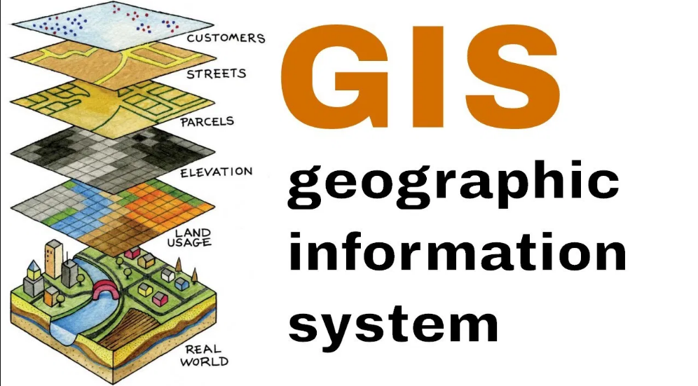
Utilizing Geographic Information Systems
Geographic Information Systems (GIS) play a crucial role in disaster preparedness by providing a comprehensive platform for storing, analyzing, and visualizing geographic data. By integrating various layers of information such as topography, population density, infrastructure, and environmental factors, GIS enables emergency responders to identify high-risk zones and vulnerable areas with precision. This valuable tool allows for the creation of accurate maps that facilitate strategic planning and the establishment of effective evacuation routes.
In addition to aiding in the identification of at-risk areas, GIS enhances the coordination of emergency response efforts by serving as a centralized system for real-time data sharing among multiple agencies. By enabling stakeholders to access up-to-date information on relief distribution, shelter locations, and damage assessments, GIS helps streamline decision-making processes and improve resource allocation during crises. Its ability to visualize crisis situations in a spatial context enables responders to better understand the scope of disasters and proactively plan for potential impacts, ultimately leading to more efficient and coordinated disaster response operations.
• GIS provides a comprehensive platform for storing, analyzing, and visualizing geographic data
• Integration of various layers such as topography, population density, infrastructure, and environmental factors helps identify high-risk zones
• Accurate maps created through GIS facilitate strategic planning and establishment of effective evacuation routes
• GIS serves as a centralized system for real-time data sharing among multiple agencies during emergency response efforts
• Stakeholders can access up-to-date information on relief distribution, shelter locations, and damage assessments through GIS
• Visualization of crisis situations in a spatial context enables better understanding of disasters and proactive planning for potential impacts
Visualizing Crisis Situations
Geospatial data and mapping technologies play a crucial role in visualizing crisis situations during disasters. By overlaying real-time information on maps, emergency responders and decision-makers gain a comprehensive understanding of the unfolding events. This visual representation allows for a quick assessment of impacted areas, population distribution, critical infrastructure, and the extent of the disaster’s impact. Such visualizations aid in identifying priorities for response efforts and allocating resources efficiently.
Moreover, the ability to visualize crisis situations enables emergency management teams to track the progression of disasters as they evolve. By observing the spatial distribution of hazards, the movement of affected populations, and the spread of damages, officials can make informed decisions in real-time. This visual clarity helps in establishing priorities for evacuation, search and rescue operations, and resource mobilization to mitigate the consequences of the disaster effectively.
• Geospatial data and mapping technologies are essential for visualizing crisis situations
• Overlaying real-time information on maps provides a comprehensive understanding of unfolding events
• Visual representations help in assessing impacted areas, population distribution, critical infrastructure, and disaster impact
• Such visualizations aid in identifying response priorities and allocating resources efficiently
Furthermore, the ability to visualize crisis situations allows emergency management teams to monitor the progression of disasters as they unfold. Observing the spatial distribution of hazards, movement of affected populations, and spread of damages enables officials to make informed decisions in real-time. This visual clarity is crucial for establishing evacuation priorities, coordinating search and rescue operations, and mobilizing resources effectively to mitigate disaster consequences.
Overall, geospatial data visualization plays a vital role in enhancing situational awareness during crises by providing decision-makers with actionable insights based on real-time information. By leveraging mapping technologies to create visual representations of disaster scenarios, emergency responders can respond promptly and effectively to mitigate risks and protect communities from harm.
Predicting Disaster Impacts
Predicting disaster impacts is a critical aspect of disaster preparedness and response. By utilizing advanced mapping technologies and geographic data, experts can forecast the potential consequences of natural calamities with more precision. These predictions help authorities understand the magnitude of a disaster, enabling them to allocate resources and plan effective response strategies in advance.
Through the analysis of historical data and the assessment of various risk factors, experts can identify vulnerable areas and populations that are most likely to be affected by disasters. This proactive approach allows for targeted interventions and the implementation of mitigation measures to reduce the impact of disasters on communities. By predicting disaster impacts accurately, stakeholders are better equipped to make informed decisions and improve overall disaster management practices.
• Predicting disaster impacts is crucial for disaster preparedness and response
• Advanced mapping technologies and geographic data help experts forecast potential consequences of natural calamities
• Predictions assist authorities in understanding the magnitude of disasters and planning effective response strategies in advance
• Analysis of historical data and assessment of risk factors helps identify vulnerable areas and populations likely to be affected by disasters
• Proactive approach allows for targeted interventions and implementation of mitigation measures to reduce impact on communities
• Accurate prediction of disaster impacts enables stakeholders to make informed decisions and improve overall disaster management practices
Supporting Search and Rescue Operations
Search and rescue operations are essential in saving lives during disasters. Through the use of maps and GIS technology, responders can efficiently locate individuals in distress and coordinate rescue efforts. By overlaying real-time data on maps, search teams can identify areas where people might be stranded and strategically deploy resources to reach them swiftly.
Moreover, by analyzing geographic data, responders can prioritize their search efforts based on the level of danger in different locations. This data-driven approach helps rescue teams allocate their resources effectively and focus on areas with the highest probability of finding survivors. The integration of mapping technology into search and rescue operations enhances the efficiency and effectiveness of response efforts, ultimately increasing the chances of saving lives in emergency situations.
• GIS technology plays a crucial role in search and rescue operations
• Real-time data overlay on maps helps identify stranded individuals
• Geographic data analysis aids in prioritizing search efforts based on danger levels
• Integration of mapping technology enhances efficiency and effectiveness of response efforts
Facilitating Decision-Making Processes
Approaching decision-making during a crisis is a multifaceted challenge that requires swift and precise actions. The integration of geographic data and mapping technologies plays a crucial role in facilitating informed decision-making processes. By visualizing data on vulnerable areas, high-risk zones, and resource distribution, decision-makers can pinpoint priorities and allocate resources efficiently.
Furthermore, the utilization of geographic information systems aids in predicting potential disaster impacts, enabling proactive measures to be taken. These predictive models based on historical data and real-time information can provide valuable insights for decision-makers to strategize response efforts effectively. By enhancing the speed and accuracy of decision-making processes, the use of geographical data fosters a more coordinated and targeted approach to managing crises.
• Geographic data and mapping technologies help visualize vulnerable areas and high-risk zones
• Decision-makers can pinpoint priorities and allocate resources efficiently
• Geographic information systems aid in predicting potential disaster impacts
• Predictive models based on historical data provide valuable insights for decision-making
• Enhances the speed and accuracy of decision-making processes
• Promotes a more coordinated and targeted approach to managing crises
Enhancing Coordination Among Agencies
Enhancing coordination among agencies is vital for effective disaster response and management. Improved communication and collaboration between different organizations can streamline efforts, prevent duplication of tasks, and ensure a more efficient allocation of resources. By sharing information, resources, and expertise, agencies can work together seamlessly to address the needs of affected populations in a timely and organized manner.
Enhanced coordination among agencies also promotes a more unified approach to decision-making during crises. By establishing clear lines of communication and protocols for exchanging critical information, agencies can make quicker and more informed decisions to better respond to the evolving situation. This collaborative effort helps to strengthen the overall resilience of communities and improve the overall effectiveness of disaster response efforts.
• Improved communication and collaboration between agencies can streamline efforts
• Prevent duplication of tasks
• Ensure a more efficient allocation of resources
• Sharing information, resources, and expertise allows agencies to work together seamlessly
• Address the needs of affected populations in a timely and organized manner
Enhanced coordination among agencies also:
• Promotes a more unified approach to decision-making during crises
• Establishes clear lines of communication and protocols for exchanging critical information
• Enables quicker and more informed decisions to respond to the evolving situation
• Strengthens the overall resilience of communities
• Improves the overall effectiveness of disaster response efforts
Engaging with Local Communities
In times of disaster, engaging with local communities is essential for effective response and recovery efforts. Local residents possess invaluable knowledge about their neighborhoods, including key infrastructure, high-risk areas, and community resources. By involving the community in planning and decision-making processes, authorities can tap into this wealth of information to develop more targeted and efficient strategies. Furthermore, fostering collaboration with local residents helps build trust and understanding, increasing the likelihood of successful outcomes during crises.
Community engagement also plays a crucial role in promoting resilience and preparedness at the grassroots level. By working closely with residents, emergency management agencies can empower communities to take proactive steps to mitigate risks, such as establishing neighborhood emergency plans and conducting evacuation drills. Through ongoing dialogue and partnership-building, authorities can cultivate a culture of shared responsibility and solidarity, where everyone plays a role in safeguarding their community against the impacts of disasters.
• Engaging with local communities is essential for effective response and recovery efforts in times of disaster
• Local residents possess invaluable knowledge about their neighborhoods, including key infrastructure, high-risk areas, and community resources
• Involving the community in planning and decision-making processes helps develop more targeted and efficient strategies
• Fostering collaboration with local residents builds trust and understanding, increasing the likelihood of successful outcomes during crises
Community engagement also plays a crucial role in promoting resilience and preparedness at the grassroots level. By working closely with residents, emergency management agencies can empower communities to take proactive steps to mitigate risks:
• Establishing neighborhood emergency plans
• Conducting evacuation drills
Through ongoing dialogue and partnership-building, authorities can cultivate a culture of shared responsibility and solidarity where everyone plays a role in safeguarding their community against the impacts of disasters.
Training Disaster Response Teams
Effective training of disaster response teams is crucial in ensuring preparedness and efficiency in times of crisis. Training programs should encompass a range of scenarios and challenges that responders may encounter, providing them with the skills and knowledge needed to act swiftly and decisively. Hands-on exercises and simulations can help team members understand their roles and responsibilities, as well as improve their ability to work collaboratively under pressure.
Regular training sessions not only help responders sharpen their individual skills but also foster a sense of teamwork and camaraderie within the unit. By practicing various response strategies and tactics, team members can gain confidence in their abilities and strengthen their capacity to adapt to the dynamic nature of emergencies. Ongoing training also allows for the identification of areas that may need improvement, enabling teams to continuously enhance their readiness and effectiveness in mitigating disaster impacts.
• Hands-on exercises and simulations are essential for helping team members understand their roles and responsibilities
• Regular training sessions help sharpen individual skills and foster teamwork within the unit
• Practicing various response strategies and tactics builds confidence in abilities
• Ongoing training allows for identification of areas needing improvement to enhance readiness
Improving Post-Disaster Recovery
Following a disaster, the focus shifts towards rebuilding and restoring affected communities to their pre-disaster state or even better. An essential aspect of improving post-disaster recovery is conducting thorough assessments to understand the extent of damage and the needs of the affected population. These assessments help in prioritizing recovery efforts and allocating resources efficiently to address immediate and long-term recovery needs.
Furthermore, engaging with local communities is crucial in post-disaster recovery efforts. Involving community members in decision-making processes and recovery planning ensures that interventions are tailored to the specific needs and context of the affected populations. Empowering communities to take an active role in their own recovery not only fosters resilience but also promotes a sense of ownership and solidarity, ultimately contributing to more sustainable and successful recovery outcomes.
• Conduct thorough assessments to understand damage and needs of affected population
• Prioritize recovery efforts based on assessment findings
• Allocate resources efficiently for immediate and long-term recovery needs
• Engage with local communities in decision-making processes
• Tailor interventions to specific needs and context of affected populations
• Empower communities to take active role in their own recovery
By following these strategies, post-disaster recovery efforts can be more effective and sustainable. Building resilience within communities not only helps them recover from the immediate impacts of a disaster but also prepares them for future challenges. Collaboration between government agencies, non-profit organizations, businesses, and community members is essential in creating a comprehensive approach to improving post-disaster recovery. Together, we can work towards building stronger, more resilient communities that are better equipped to handle disasters and emerge stronger in the aftermath.
Ensuring Effective Resource Allocation
Effective resource allocation is crucial in ensuring that assistance reaches those in need during times of disaster. By carefully assessing the situation on the ground and understanding the specific needs of affected populations, organizations can strategically allocate resources to provide essential services such as food, water, shelter, and medical care. This targeted approach helps in optimizing the impact of resources and maximizing the effectiveness of relief efforts.
Furthermore, by continuously monitoring the distribution and utilization of resources, agencies can quickly identify any gaps or areas where additional support may be required. This real-time tracking allows for adjustments to be made in response to changing needs, ensuring that resources are directed where they are most needed. Overall, effective resource allocation not only helps in meeting immediate needs but also paves the way for sustainable recovery and resilience building in communities grappling with the aftermath of a disaster.
• By carefully assessing the situation on the ground, organizations can understand specific needs
• Targeted approach helps in optimizing impact of resources
• Continuous monitoring allows for quick identification of gaps or areas needing additional support
• Real-time tracking enables adjustments to be made in response to changing needs
• Effective resource allocation paves way for sustainable recovery and resilience building


