
What Causes Earthquakes
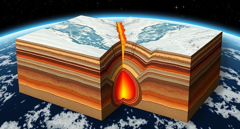
Earthquakes are natural phenomena that occur when there is a sudden release of energy in the Earth’s crust. This release of energy causes seismic waves to propagate through the Earth, resulting in ground shaking. The primary cause of earthquakes is the movement of tectonic plates, which make up the Earth’s outer shell. These plates are constantly in motion, either colliding, sliding past each other, or moving apart.
When the stress between two tectonic plates exceeds the strength of the rocks holding them together, it leads to a sudden release of energy in the form of an earthquake. This can happen along faults, which are fractures in the Earth’s crust where rocks on either side have moved relative to each other. The movement along faults can be gradual and imperceptible, or sudden and catastrophic, depending on the amount of stress accumulated and the type of fault involved.
• Earthquakes are natural phenomena caused by a sudden release of energy in the Earth’s crust
• The primary cause of earthquakes is the movement of tectonic plates making up the Earth’s outer shell
• Tectonic plates are constantly in motion, colliding, sliding past each other, or moving apart
• Stress between two tectonic plates exceeding rock strength leads to an earthquake
• Earthquakes can occur along faults, which are fractures in the Earth’s crust where rocks have moved relative to each other
Plate Tectonics and Earthquakes
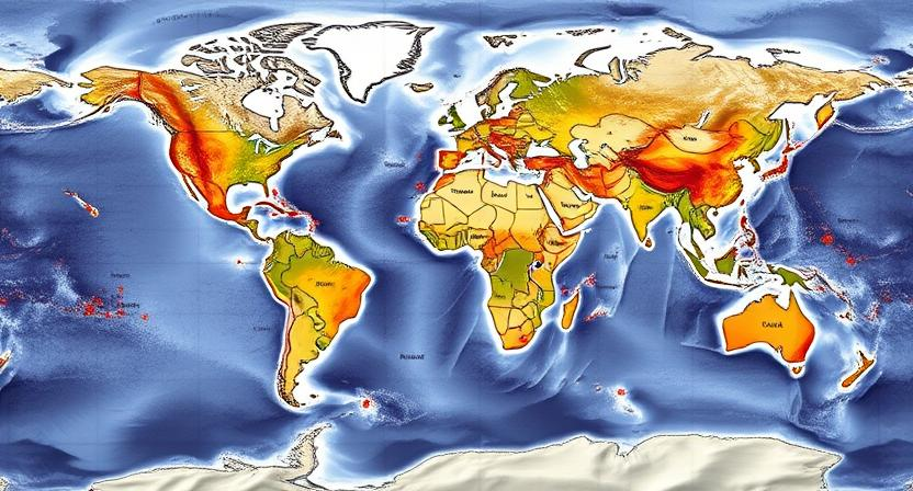
Along the boundaries of tectonic plates, where these massive slabs of the Earth’s lithosphere meet and interact, earthquakes are often a common occurrence. The movement and collision of these plates create immense geological stresses that eventually lead to the release of energy in the form of seismic waves. This is why regions such as the Pacific Ring of Fire, where multiple tectonic plates converge, experience frequent and intense seismic activity.
The concept of plate tectonics provides a fundamental framework for understanding the relationship between the movement of the Earth’s lithospheric plates and the occurrence of earthquakes. As plates interact by either converging, diverging, or sliding past one another, the resulting interactions can generate various types of faults that are crucial in the generation of seismic activity. The study of plate tectonics not only helps in explaining the distribution of earthquakes but also aids in predicting potential seismic hazards in different regions across the globe.
• Along the boundaries of tectonic plates, earthquakes are common occurrences
• Movement and collision of plates create geological stresses leading to seismic waves
• Regions like the Pacific Ring of Fire experience frequent and intense seismic activity
• Plate tectonics framework helps understand relationship between plate movement and earthquakes
• Interactions of plates can generate different types of faults crucial for seismic activity
• Study of plate tectonics aids in explaining earthquake distribution and predicting seismic hazards
Types of Faults
There are three primary types of faults: normal faults, reverse faults, and strike-slip faults. Normal faults are caused by tensional forces, where the hanging wall moves downward relative to the footwall. Reverse faults, on the other hand, occur when compressional forces lead to the hanging wall moving upward relative to the footwall. Finally, strike-slip faults involve horizontal movement along the fault line, with the two blocks moving past each other laterally. Understanding the type of fault present in a region is crucial for assessing seismic hazards and risks.
Each type of fault exhibits distinctive characteristics in terms of the orientation of the fault plane and the movement of the blocks. Normal faults are typically identified by steeply-dipping fault planes and the presence of fault scarps where the hanging wall has moved down. Reverse faults, on the other hand, often display a more shallow angle of fault planes and fault bends that create thrust faults. Strike-slip faults are recognized by horizontal movement without significant vertical displacement. Studying these fault types is essential for comprehending the complexities of earthquake generation and propagation.
• Normal faults are caused by tensional forces
• Reverse faults occur due to compressional forces
• Strike-slip faults involve horizontal movement along the fault line
• Normal faults have steeply-dipping fault planes and fault scarps
• Reverse faults have shallow angle fault planes and thrust faults
• Strike-slip faults exhibit horizontal movement without significant vertical displacement
By understanding these different types of faults, scientists can better predict seismic activity and mitigate potential risks associated with earthquakes. The study of fault types also helps in identifying regions that are more prone to seismic hazards, allowing for better disaster preparedness and response strategies. As research continues to advance in the field of seismology, our understanding of fault types will only improve, leading to enhanced safety measures for communities living in earthquake-prone areas.
Seismology: The Study of Earthquakes
Seismology delves into the intricate study of earthquakes, aiming to decipher the mechanisms behind these powerful natural phenomena. By analyzing seismic waves generated during an earthquake, seismologists can unravel valuable insights into the Earth’s structure and composition. Through the deployment of seismographs and seismometers, they can meticulously record the propagation of seismic waves across the globe, providing a deeper understanding of earthquake dynamics.
Furthermore, seismology plays a crucial role in assessing seismic hazards and assessing the potential risks posed by earthquakes. By determining the location and magnitude of an earthquake, seismologists can offer vital information for disaster preparedness and risk mitigation strategies. This discipline not only aids in predicting ground shaking intensity but also contributes to the development of early warning systems, offering precious seconds or minutes for people to seek safety during an impending earthquake.
• Seismology helps decipher mechanisms behind earthquakes
• Analysis of seismic waves reveals insights into Earth’s structure and composition
• Deployment of seismographs and seismometers record propagation of seismic waves globally
• Assessing seismic hazards and risks is a crucial role of seismologists
• Determining location and magnitude aids in disaster preparedness strategies
• Contribution to development of early warning systems for earthquake safety
The Richter Scale
The Richter Scale, developed in 1935 by Charles F. Richter and Beno Gutenberg, is a logarithmic scale used to measure the magnitude of earthquakes. The scale ranges from 0 to 10, with each whole number increase representing a tenfold increase in the amplitude of seismic waves. For example, an earthquake with a magnitude of 5 releases 10 times more energy than an earthquake with a magnitude of 4.
The Richter Scale is a valuable tool for seismologists to compare the size of earthquakes based on the amplitude of seismic waves recorded by seismographs. However, it has limitations, as it works best for measuring smaller earthquakes that are close to the seismograph. For larger earthquakes or those occurring far from the measurement device, other scales like the Moment Magnitude Scale are more suitable for accurately determining the earthquake magnitude.
• The Richter Scale is a logarithmic scale used to measure the magnitude of earthquakes
• Developed in 1935 by Charles F. Richter and Beno Gutenberg
• Ranges from 0 to 10, with each whole number increase representing a tenfold increase in seismic wave amplitude
• Useful for comparing earthquake sizes based on recorded seismic waves
• Works best for measuring smaller earthquakes close to the seismograph
• Limitations include accuracy for larger earthquakes or those far from measurement device
The Moment Magnitude Scale
The Moment Magnitude Scale is a method used to measure the size of earthquakes based on the energy released during the event. Unlike the Richter scale, which was commonly used in the past, the Moment Magnitude Scale takes into account the actual seismic moment of an earthquake, providing a more accurate representation of its true magnitude. This scale is now the preferred choice for assessing earthquake size by seismologists and researchers around the world.
One of the key advantages of the Moment Magnitude Scale is its ability to accurately measure the size of very large earthquakes that may have been underestimated when using older scales. By considering the total energy released by an earthquake, this scale provides a more reliable assessment of its impact on the surrounding areas. The Moment Magnitude Scale offers a standardized way to categorize earthquakes based on their magnitude, allowing for easier comparison and analysis of seismic activity across different regions and time periods.
• The Moment Magnitude Scale takes into account the actual seismic moment of an earthquake
• Provides a more accurate representation of the true magnitude of earthquakes
• Preferred choice for assessing earthquake size by seismologists and researchers worldwide
• Accurately measures the size of very large earthquakes that may have been underestimated with older scales
• Considers total energy released by an earthquake for a more reliable impact assessment
• Offers standardized categorization of earthquakes based on magnitude for easier comparison and analysis across regions and time periods
Measuring Ground Acceleration
Ground acceleration is a crucial parameter in understanding the intensity and impact of earthquakes. It refers to the rate at which the velocity or speed of an object changes over time due to seismic waves. Measuring ground acceleration is essential for determining the amount of force exerted on structures and the ground during an earthquake.
Seismometers are commonly used to measure ground acceleration by detecting the velocity of the ground motion. These instruments can provide accurate data on the acceleration experienced at a specific location during an earthquake. By analyzing this data, scientists and seismologists can better assess the potential risk and damage caused by seismic events.
• Ground acceleration is a key parameter in earthquake analysis
• It measures the rate of change in velocity due to seismic waves
• Measuring ground acceleration helps determine force on structures during earthquakes
Seismometers are essential tools for measuring ground acceleration
They detect the velocity of ground motion accurately
Data from seismometers aids scientists in assessing earthquake risks and potential damage
Seismographs and Seismometers
Seismographs are instruments used to detect and record the vibrations caused by earthquakes. They consist of a mass suspended on a spring within a frame that remains stationary during ground movement. When an earthquake occurs, the ground shakes, causing the seismograph’s frame to move with the ground while the mass remains relatively motionless due to inertia. This displacement between the frame and the mass is converted into a record of the ground motion, which is then used to study the characteristics of the earthquake.
Seismometers are sensors at the heart of seismographs that measure the motion of the ground. These sensors can detect both the amplitude and frequency of ground movements during an earthquake. The data collected by seismometers are crucial for seismologists to analyze and understand the characteristics of seismic waves produced by earthquakes. By examining these recordings, scientists can determine the location, magnitude, and depth of an earthquake, providing valuable information for assessing potential hazards and risks associated with seismic events.
• Seismographs are instruments used to detect and record vibrations caused by earthquakes
• Consist of a mass suspended on a spring within a frame
• Frame remains stationary during ground movement
• Displacement between frame and mass converted into record of ground motion
• Seismometers are sensors at the heart of seismographs
• Measure motion of the ground during earthquakes
• Detect both amplitude and frequency of ground movements
• Data collected crucial for seismologists to analyze seismic waves
By utilizing seismographs and seismometers, scientists can gain valuable insights into earthquake characteristics. The data collected from these instruments help in understanding the behavior of seismic events, which is essential for assessing risks associated with earthquakes. With advancements in technology, seismologists continue to improve their ability to predict, monitor, and respond to seismic activity around the world.
The Role of P Waves and S Waves
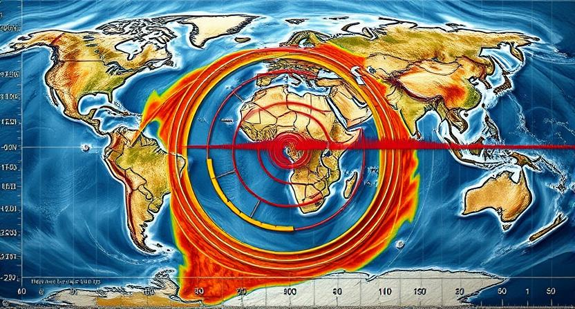
P waves, also known as compressional waves or primary waves, are the fastest seismic waves generated by an earthquake. They are the first to be recorded on a seismograph and can travel through both solids and liquids. P waves cause particles in the rock to move in the same direction as the wave itself, creating a back-and-forth motion. This helps scientists determine the location of an earthquake’s epicenter and the time it occurred with greater accuracy.
In contrast, S waves, also called shear waves or secondary waves, are slower than P waves and can only travel through solids. S waves cause particles in the rock to move perpendicular to the direction of the wave, creating a side-to-side motion. The arrival of S waves signals the onset of more destructive shaking and can help seismologists estimate the magnitude of an earthquake. By analyzing the arrival times of P and S waves at different seismograph stations, researchers can better understand the characteristics of seismic events and improve their ability to monitor and study earthquakes.
• P waves, also known as compressional waves or primary waves, are the fastest seismic waves generated by an earthquake.
• They are the first to be recorded on a seismograph and can travel through both solids and liquids.
• P waves cause particles in the rock to move in the same direction as the wave itself, creating a back-and-forth motion.
• This helps scientists determine the location of an earthquake’s epicenter and the time it occurred with greater accuracy.
• In contrast, S waves, also called shear waves or secondary waves, are slower than P waves and can only travel through solids.
• S waves cause particles in the rock to move perpendicular to the direction of the wave, creating a side-to-side motion.
• The arrival of S waves signals the onset of more destructive shaking and can help seismologists estimate the magnitude of an earthquake.
• By analyzing the arrival times of P and S waves at different seismograph stations, researchers can better understand characteristics of seismic events.
Measuring Earthquake Intensity
Measuring earthquake intensity is a crucial aspect of understanding the impact of seismic events on the earth’s surface. One of the most commonly used scales for measuring earthquake intensity is the Modified Mercalli Intensity Scale, which ranges from I to XII and provides a subjective assessment of the effects of an earthquake at a specific location. This scale takes into account various factors such as the level of shaking, damage to structures, and effects on people and the environment.
In addition to the Modified Mercalli Intensity Scale, scientists also use other methods to measure earthquake intensity, including quantitative scales like the moment magnitude scale. This scale calculates the total energy released by an earthquake based on the seismic waves it generates, providing a more objective measurement of an earthquake’s intensity compared to the Mercalli scale. By combining both subjective and objective measures of earthquake intensity, researchers are able to gain a more comprehensive understanding of the impact of seismic events on society and the environment.
• Measuring earthquake intensity is crucial for understanding seismic events
• Modified Mercalli Intensity Scale ranges from I to XII
• Provides subjective assessment of effects at specific locations
• Considers factors like shaking, damage, and effects on people/environment
• Moment magnitude scale calculates total energy released by earthquake
• Based on seismic waves generated
• Provides more objective measurement compared to Mercalli scale
By utilizing both subjective and objective measures of earthquake intensity, researchers can better understand the impact of seismic events on society and the environment. This comprehensive approach allows for a more accurate assessment of the effects of earthquakes and helps in developing strategies to mitigate their impact in the future.
Understanding the Modified Mercalli Intensity Scale
The Modified Mercalli Intensity Scale, developed by Italian seismologist Giuseppe Mercalli in 1902, is a way of measuring the intensity of shaking produced by an earthquake. Unlike the Richter or Moment Magnitude Scale that measure the magnitude of an earthquake, the Mercalli Scale focuses on the effects of the earthquake on people, buildings, and the environment. The scale ranges from I (not felt) to XII (total destruction), with each level describing the perceived intensity of the earthquake at a specific location.
This scale takes into account factors such as the distance from the epicenter, the type of ground material, and local building practices to determine the intensity level experienced in a particular area. By gathering reports from eyewitnesses and assessing damage to structures, scientists can assign an intensity level to different locations affected by an earthquake. The Modified Mercalli Intensity Scale provides valuable information about the impact of earthquakes on society and infrastructure, helping to improve building codes and emergency preparedness measures in earthquake-prone regions.
• The Modified Mercalli Intensity Scale was developed by Italian seismologist Giuseppe Mercalli in 1902
• It measures the intensity of shaking produced by an earthquake, focusing on its effects on people, buildings, and the environment
• The scale ranges from I (not felt) to XII (total destruction), with each level describing the perceived intensity at a specific location
• Factors such as distance from the epicenter, ground material type, and local building practices are taken into account to determine intensity levels
• Gathering reports from eyewitnesses and assessing damage helps assign intensity levels to different locations affected by earthquakes
The Modified Mercalli Intensity Scale is crucial for understanding how earthquakes impact society and infrastructure. By providing valuable information about the effects of seismic activity in different areas, this scale aids in improving building codes and emergency preparedness measures in regions prone to earthquakes. Scientists use this scale to assess the severity of shaking experienced during an earthquake event, helping communities better prepare for future disasters. Through careful analysis of data collected using the Mercalli Scale, researchers can gain insights into how seismic waves propagate through various terrains and structures.
The Importance of Epicenters
To better understand earthquakes, pinpointing the location of the epicenter is crucial. The epicenter is the point on the Earth’s surface directly above the focus or hypocenter, where the earthquake originates. By identifying the epicenter, scientists can determine the geographic region most affected by the seismic waves, enabling emergency response teams to act swiftly in deploying resources and aid to the impacted areas.
Moreover, studying the distribution of epicenters along fault lines helps seismologists map out areas of high seismic activity. This information is essential for assessing the level of seismic hazard in different regions and developing effective strategies for earthquake preparedness and mitigation. By analyzing epicenters, researchers can also gain insights into the tectonic forces at play, providing valuable data for understanding the underlying causes of earthquakes and potentially predicting future seismic events.
• Pinpointing the location of the epicenter is crucial for understanding earthquakes
• The epicenter is directly above the focus or hypocenter where the earthquake originates
• Identifying the epicenter helps determine the most affected geographic region by seismic waves
• Helps emergency response teams deploy resources and aid to impacted areas swiftly
• Studying distribution of epicenters along fault lines maps out high seismic activity areas
• Essential for assessing level of seismic hazard in different regions
• Aids in developing effective strategies for earthquake preparedness and mitigation
• Analyzing epicenters provides insights into tectonic forces at play
• Valuable data for understanding underlying causes of earthquakes
• Potentially aids in predicting future seismic events
The Depth of Earthquakes
The depth at which an earthquake originates within the Earth’s crust plays a crucial role in determining the potential impact it may have on the surface. Earthquakes can occur at varying depths, ranging from shallow depths of less than 70 kilometers to intermediate depths between 70 and 300 kilometers, and deep depths of more than 300 kilometers. Shallow earthquakes, originating close to the Earth’s surface, tend to cause the most destruction due to their proximity to populated areas and infrastructure. On the other hand, deep earthquakes, which occur within the Earth’s mantle, usually result in less surface damage despite their potential to generate powerful seismic waves that can be felt over vast distances.
The depth of an earthquake is closely related to the type of tectonic plate boundary at which it occurs. Shallow earthquakes are commonly associated with transform and divergent plate boundaries, where tectonic plates slide past each other or move apart. Intermediate and deep earthquakes, on the other hand, often occur near convergent plate boundaries, where plates collide and one is forced below the other in a process known as subduction. The depth of earthquakes provides valuable insights into the geological processes taking place beneath the Earth’s surface, contributing to our understanding of plate tectonics and seismic activity.
• Shallow earthquakes, occurring at depths of less than 70 kilometers, pose a greater threat to populated areas and infrastructure due to their proximity to the surface.
• Deep earthquakes, originating more than 300 kilometers below the surface within the Earth’s mantle, can generate powerful seismic waves but typically cause less surface damage.
• The depth of an earthquake is influenced by the type of tectonic plate boundary at which it occurs. Shallow earthquakes are commonly associated with transform and divergent plate boundaries, while intermediate and deep earthquakes often occur near convergent plate boundaries where subduction takes place.
• Understanding the depth of earthquakes provides valuable insights into geological processes beneath the Earth’s surface and contributes to our knowledge of plate tectonics and seismic activity.
Factors Affecting Earthquake Magnitude
Factors affecting earthquake magnitude include the size of the fault rupture and the amount of slip along the fault plane. Larger faults with significant slip have the potential to generate more powerful earthquakes compared to smaller faults with less slip. The amount of stress accumulated over time along a fault also plays a crucial role in determining the magnitude of an earthquake, as higher stress levels can lead to more intense seismic events.
Additionally, the type of rock and the depth at which the earthquake occurs can influence its magnitude. Deeper earthquakes tend to produce higher magnitudes due to the increased pressure and energy involved in the process. The composition of the Earth’s crust in a particular region, as well as the presence of any existing geological structures, can further impact the magnitude of an earthquake by influencing the propagation of seismic waves and the release of stored energy.
• Larger faults with significant slip can generate more powerful earthquakes
• Amount of stress accumulated over time along a fault affects earthquake magnitude
• Type of rock and depth at which earthquake occurs can influence magnitude
• Deeper earthquakes tend to produce higher magnitudes due to increased pressure and energy
• Composition of Earth’s crust in a region and existing geological structures impact earthquake magnitude
The Relationship Between Earthquakes and Tsunamis
Earthquakes can trigger tsunamis when they occur in underwater settings. The sudden vertical movement of the seafloor during an earthquake can displace a large volume of water, setting off a series of powerful ocean waves. These waves can travel across vast distances, reaching shorelines and causing devastating destruction in coastal areas.
The relationship between earthquakes and tsunamis highlights the interconnected nature of geophysical phenomena. While not all earthquakes lead to tsunamis, those that do can have catastrophic consequences. Understanding the mechanisms behind this relationship is crucial for developing effective warning systems and mitigating the impact of these natural disasters on vulnerable communities.
• Earthquakes can trigger tsunamis when they occur in underwater settings.
• The sudden vertical movement of the seafloor during an earthquake can displace a large volume of water, setting off a series of powerful ocean waves.
• These waves can travel across vast distances, reaching shorelines and causing devastating destruction in coastal areas.
The relationship between earthquakes and tsunamis highlights the interconnected nature of geophysical phenomena. While not all earthquakes lead to tsunamis, those that do can have catastrophic consequences. Understanding the mechanisms behind this relationship is crucial for developing effective warning systems and mitigating the impact of these natural disasters on vulnerable communities.
The Frequency of Earthquakes
The Earth is a dynamic planet, constantly shifting and evolving, which is evident in the frequency of earthquakes occurring worldwide. On average, there are around 50,000 earthquakes each year, with the vast majority being too small to be felt by humans. These seismic events vary in magnitude and intensity, with some regions experiencing more earthquakes than others due to tectonic plate boundaries and geological structures.
The frequency of earthquakes is not evenly distributed across the globe, with certain areas known for their high levels of seismic activity. The “Ring of Fire,” a horseshoe-shaped zone encircling the Pacific Ocean, is notorious for its frequent earthquakes and volcanic eruptions due to the interactions of several tectonic plates. Additionally, regions along major fault lines such as the San Andreas Fault in California also experience a higher frequency of earthquakes compared to more stable areas. Understanding the distribution and frequency of earthquakes is crucial for preparedness and mitigation efforts to minimize the impact of these natural disasters on human lives and infrastructure.
• The Earth is a dynamic planet, constantly shifting and evolving
• On average, there are around 50,000 earthquakes each year
• Majority of earthquakes are too small to be felt by humans
• Seismic events vary in magnitude and intensity
• Certain areas known for high levels of seismic activity
The frequency of earthquakes is not evenly distributed across the globe. Some regions experience more earthquakes than others due to tectonic plate boundaries and geological structures. For example:
• The “Ring of Fire” encircling the Pacific Ocean is notorious for frequent earthquakes and volcanic eruptions
• Regions along major fault lines like the San Andreas Fault in California also experience higher frequency of earthquakes compared to stable areas
Understanding the distribution and frequency of earthquakes is crucial for preparedness efforts. It helps in developing mitigation strategies to minimize the impact of these natural disasters on human lives and infrastructure.
Historical Earthquakes and Their Impacts
Throughout history, there have been several catastrophic earthquakes that have left lasting impacts on societies and landscapes. One notable event is the Great Lisbon earthquake of 1755, which struck Portugal and neighboring countries with devastating force. The earthquake, estimated to have been around 8.5-9.0 magnitude, triggered a tsunami that further wreaked havoc along the coastlines. The city of Lisbon was almost entirely destroyed, with tens of thousands of lives lost and significant cultural and architectural heritage wiped out in the aftermath. The Great Lisbon earthquake serves as a somber reminder of the destructive power that seismic events can unleash upon unsuspecting populations.
Another significant historical earthquake is the 1906 San Francisco earthquake in California, United States. This earthquake, with an estimated magnitude of 7.8, caused widespread destruction in the city of San Francisco and the surrounding areas. The shaking and subsequent fires resulted in thousands of casualties and left hundreds of thousands of people homeless. The 1906 San Francisco earthquake led to major advancements in earthquake engineering and building codes to better prepare for and mitigate the impacts of future seismic events. The aftermath of this earthquake highlighted the importance of proper urban planning and disaster preparedness in earthquake-prone regions.
• The Great Lisbon earthquake of 1755 had an estimated magnitude of 8.5-9.0
• It triggered a devastating tsunami that caused further destruction along coastlines
• Tens of thousands of lives were lost and significant cultural heritage was wiped out in Lisbon
• The earthquake serves as a reminder of the destructive power of seismic events
• The 1906 San Francisco earthquake had an estimated magnitude of 7.8
• It caused widespread destruction, casualties, and left hundreds of thousands homeless
• Major advancements in earthquake engineering and building codes were made after this event
• Highlighted the importance of proper urban planning and disaster preparedness for future seismic events
Predicting Earthquakes: Challenges and Limitations
Predicting earthquakes poses numerous challenges due to the complex and unpredictable nature of these geological events. Despite significant advancements in technology and scientific understanding, accurately forecasting when and where an earthquake will occur remains elusive. Scientists face limitations in deciphering the underlying mechanisms and intricacies of the Earth’s crust that lead to seismic activity. The sheer variety of factors that contribute to the occurrence of earthquakes, such as plate movements, fault interactions, and rock mechanics, make it difficult to establish reliable prediction methods.
Moreover, the lack of clear precursory signals and patterns preceding an earthquake further compounds the challenge of forecasting such events. While certain phenomena like foreshocks can sometimes provide clues about imminent seismic activity, not all earthquakes exhibit these warning signs. The intermittent and sporadic nature of seismic events adds to the complexity of predicting earthquakes with accuracy and certainty. As research in the field of seismology continues to evolve, scientists strive to enhance forecasting capabilities and develop more effective earthquake early warning systems.
• Despite advancements in technology and scientific understanding, accurately predicting earthquakes remains difficult
• Limitations in deciphering the mechanisms of seismic activity in the Earth’s crust
• Various factors like plate movements, fault interactions, and rock mechanics make prediction challenging
• Lack of clear precursory signals and patterns before earthquakes adds to the challenge
• Not all earthquakes exhibit warning signs like foreshocks
• The intermittent and sporadic nature of seismic events complicates accurate prediction efforts
• Scientists are working to improve forecasting capabilities and develop better early warning systems for earthquakes
Earthquake Early Warning Systems
Earthquake early warning systems have become crucial tools in minimizing the impacts of seismic events. These systems are designed to detect the initial tremors of an earthquake before the more destructive waves arrive, providing valuable seconds to potentially issue warnings and take protective actions. By utilizing a network of sensors placed strategically across seismic zones, these systems can rapidly assess the magnitude of an earthquake and estimate the potential ground shaking intensity in different areas.
The effectiveness of earthquake early warning systems lies in their ability to quickly disseminate alerts to a wide range of stakeholders, from government agencies to public safety officials and the general population. These warnings can trigger automated responses such as slowing down trains, halting industrial processes, or prompting individuals to seek shelter in a safe location. While not foolproof, these systems have shown promise in saving lives and reducing damage by allowing for timely preparations and responses in earthquake-prone regions.
• Earthquake early warning systems detect initial tremors before destructive waves
• Provide valuable seconds to issue warnings and take protective actions
• Utilize network of sensors in seismic zones to assess earthquake magnitude
• Estimate potential ground shaking intensity in different areas
The rapid dissemination of alerts by earthquake early warning systems is crucial for their effectiveness. Alerts reach government agencies, public safety officials, and the general population quickly, allowing for automated responses like slowing down trains or prompting individuals to seek shelter. While not perfect, these systems have proven to save lives and reduce damage by enabling timely preparations and responses in earthquake-prone regions.
The Future of Earthquake Monitoring and Research
In the future, advancements in technology will continue to revolutionize earthquake monitoring and research. Innovations such as high-resolution satellite imaging, artificial intelligence algorithms, and machine learning techniques will enable scientists to analyze seismic data with greater accuracy and efficiency. These technological developments will not only enhance our understanding of Earth’s tectonic processes but also improve our ability to predict and mitigate the impacts of future earthquakes.
Furthermore, international collaboration and coordination will play a crucial role in the future of earthquake monitoring and research. By sharing data, resources, and expertise across borders, scientists can work together to develop more comprehensive earthquake early warning systems and improve disaster preparedness strategies. Global initiatives aimed at standardizing monitoring techniques and data sharing protocols will pave the way for a more unified and coordinated approach to earthquake research, ultimately leading to more effective earthquake prediction and risk reduction efforts.
• High-resolution satellite imaging will provide detailed views of fault lines and seismic activity
• Artificial intelligence algorithms can help identify patterns in seismic data that may indicate potential earthquake risks
• Machine learning techniques can improve the accuracy of earthquake forecasting models
• International collaboration allows for the sharing of resources, data, and expertise to enhance earthquake monitoring efforts
• Standardizing monitoring techniques and data sharing protocols on a global scale will lead to more effective earthquake prediction strategies


